Introduction
Counter Unmanned Aerial Systems (sometimes shortened to Counter-UAS, or C-UAS) is a doctrine around, well, countering UAS. UAS threats range from uneducated or careless operators or State actors utilizing them, and every scenario in between. UAS provides malicious and hostile actors with key asymmetry from a capability and financial perspective. There are thousands of COTS airframes and even more 3D-printed components and kits.
With a wide variety of optics and other sensors (not to mention kinetic payloads), UAS can quickly exhaust air defense capabilities as well as cognitively overload analysts. In the recent weeks (as of March 2026), there have been several incursions over CONUS military bases such as Barksdale Air Force Base in Shreveport, Louisiana and Fort McNair in Washington D.C. that largely went uncontested. Aside from that, airports in Denmark, Norway, and Germany were forced to temporarily shut down operations, not to mention the Gatwick Incident from 2018 that first brought C-UAS into the common conscience.
As is the case in any force protection or cyber operations setting, the attackers only need to get through once while we need to be right all the time. Complicating C-UAS further are civilian considerations, especially CONUS and outside of active warzones, the effectiveness of our sensors is degraded due to the environment, and the magazine depth of soft-kill and hard-kill weaponry is severely degraded due to the lack of options.
In active warzones, the calculus is not much better, relatively low-cost One-Way Attack (OWA) drones such as Shahed and Geran class delta-wing drones are the new musket. These OWAs range in price tag by country and modalities (e.g., prop-driven Geran-2 versus jet-powered Geran-3 and Geran-5) which consistently overwhelming high-performance NATO and domestic AD and C-UAS systems and achieving terrifying effects despite high Probability of Kill (pKill) against them. No matter the operational environment, we owe it to ourselves and to the populace we are charged with protecting to have the most capable C-UAS programs.
In this blog you will learn about what the C-UAS mission is as well as the Joint All-Domain Command & Control (JADC2) aligned "Sense - Make Sense - Act" continuum is applied across various sensor families, sensor fusion, and effectors along with their contraindications and interoperability characteristics. Additionally, you will learn about deployment considerations beyond interoperability to deal with some of the drawbacks. Finally, we'll close with what you can start doing today and some ways that Empyrean Defense can help. This blog isn't a sales pitch, we're not gating it on purpose, so folks can learn and refine their tradecraft and C-UAS programs and maybe work with us on this problem too! Ready to clap some drones?
What is Counter-UAS?
The United States Department of Homeland Security (DHS) in their Counter-UAS video defines it as "... the ability to track, identify and classify hostile UAS threats, determine the proper mitigation strategy..." whereas in ATP 3-01.81: Counter-Unmanned Aircraft System (C-UAS) there is a much more detailed Defensive and Offensive track focusing on survivability and hard-defeat mechanisms, respectively. While we at Empyrean Defense don't prescribe a specific order of operations in our C-UAS and Force Protection capability, there are benefits to doctrinal (or at least behavioral) approaches to C-UAS.
At the end of the day, C-UAS (or "counter-drone") needs to fit your operating environment and your capabilities. Shooting AIM120s from a NASAMs battery at Geran-3's may suffice in Poltava or Kyiv (horrible economic asymmetry aside), but at LaGuardia Airport (LGA) or Ronald Reagan Washington National Airport (DCA) your effectors and overall detection will be much different. You must work backwards from your threat environment and your rules of engagement.
When you add in your operating environment and your physical environment (weather, terrain, urbanization) you will "rebalance" the equation of what is useful across the Sense-Make Sense-Act continuum we preach about here at Empyrean Defense in regards to Joint All-Domain Command & Control (JADC2) doctrine. In certain cases, the environment may help you, but in many more cases it is more of an operational hinderance to plan around.
A more succinct way to think about C-UAS therefore is any activity you take to detect and identify salient UAS threats and any subsequent activity you take to prevent confirmed or suspected UAS threats from impacting your mission. If you are protecting critical infrastructure from one-way attack (OWA) drones, that may require kinetic interception, and if you are protecting a CONUS airfield that may be soft-kill effects on the UAS, halting air traffic, and interdicting the pilot if you can. Similarly, C-UAS may just be passively shielding yourself from potential UAS using coverage and concealment, and/or retreating beyond the ranges of UAS platforms used by your adversary.
Now that you know the "what", let's get into the "how" in a variety of ways.
How to Conduct Counter-UAS: Sense
Before any Courses of Action (COAs) can be generated, or any interdiction plans be set into motion, you must first detect and confirm Positive Identification (PID) against potential UAS. This is more crucial for force protection and C-UAS use cases in protected airspace or areas where there are civilians nearby - especially if an explosive, direct-energy, or small-arms based COA is in your tool bag. There are large variety of sensors that can be used for the Sense part of the C-UAS mission, we won't name anyone in particular (unless you're a Partner!) but will keep it high level around the capability.
Cooperative Radio Frequency (RF) Sensors
A cooperative RF sensor in the C-UAS sense is like Automatic Dependent Surveillance - Broadcast (ADS-B) for general aviation; these sensors pick up on broadcasted drone identification such as Open Drone ID or DJI Remote ID. There are several open source and commercial offerings that vary in the hardware, the number of targets tracked, the types of "drone ID" that are supported, as well as the range.
(Author's Note: Certain classes of UAS are required to also be equipped with ADS-B Out or UAT transmitters on 1090/978 MHz, respectively, which can provide yet an additional cooperative broadcast source.)
The main thing is that this relies on the UAS broadcasting this data; a determined adversary will either disable this functionality or opt for airframes that do not contain a transmitter. However, this is a great ground truth and an easy win.
While the operator may not have malicious intentions, nosy drone operators can still disrupt airport and seaport operations, fire & rescue, law enforcement, and/or military operations by wanting to fly their drones nearby to record videos or see what is going on for their own curiosity. Drone IDs have the benefit of not only broadcasting the exact Position Location Information (PLI) of the airframe but also the operator's location, making it much easier to interdict or otherwise confront the operator.
These broadcasts typically comply with ASTM F3411 Specification for Remote ID and Tracking or ASD-STAN prEN 4709-002 Direct Remote Identification which also conform with the stipulations of the United States Federal Aviation Administration (FAA) Part 89 Remote Identification of Unmanned Aircraft US Code. These broadcasts are typically available within the US, the European Union (EU), and Japan as standalone or embedded transmitters.
These transmissions for Remote ID typically happen over UAS control channels across 900Mhz ISM, 2.4GHz ISM, 5.0GHz ISM, and 5.8GHz ISM bands in the US that are directly part of the signal chain or using Bluetooth and/or Wi-Fi 802.11. That is not an exhaustive list by far, there are alternate control channels and differing RF mechanisms for Command & Control (C2), not to mention cellular, satellite, and/or fiber optic or completely autonomous platforms that are vision- and/or inertially guided.
Higher-end commercial offerings typically come with high gain sector or omni directional antennas, when combined with elevated masts and towers they can pick up on relatively weak powered broadcasts over distances that can match or exceed manufacturer's advertised distances for LOS and BVLOS flight operations.
Certain types of drones such as DJI and other commercial-specific drones typically embed this data within their control data link. For instance, DJI drones use 2.4GHz and 5.8GHz ISM bands with Orthogonal Frequency Divided Multiplexing (OFDM) and embedded their Remote ID packets within the bitstream. Other drones that use LTE/5G or satellite guidance may use similar mechanisms, which will require a manufacturer's specific hardware such as the old DJI AeroScope to easily decode and track these cooperative broadcasts.
The contraindications with this manner of detection are that adversaries can spoof or replay this type of data; the data structure is well known, and there are dedicated projects meant to spoof them. The economics are on the side of the adversary too, cheap promiscuous Wi-Fi dongles and even ESP32 boards can be used and power spoofed drone swarms which can overwhelm or otherwise mask your sensors. Ultimately, you will require sensor fusion software or another physics-driven mechanism to detect impossible or improbable maneuvers and loitering from spoofing attacks against their alleged kinematics.
Signals Intelligence (SIGINT) Sensors
Generic SIGINT sensors refer to any class of sensor that can detect and PID RF characteristics and even extend to providing dual-use in the form of soft-kill capabilities or different radio direction finding techniques. For Counter-UAS, these are typically Software Defined Radios (SDRs) with high performance oscillators, ADCs, and filters or amplifiers tuned against well-known UAS control frequencies. More than that, they have Digital Signal Processing (DSP) capabilities with signature- and heuristic-based detection mechanisms that can discriminate UAS control channels against other RF sources such as Land Mobile Radio (LMR), cellular towers, and other background electromagnetic noise.
The benefit to these types of sensors is that they can work with other C-UAS sensors to provide more detailed information that can corroborate what they're sensing or be used as a mechanism to detect spoofing, jamming, or replay attacks of cooperative broadcasts such as Remote ID. In certain electromagnetic environments, these SIGINT sensors can also be used to detect cellular-operated drones or even drones running custom signal stacks in non-traditional frequencies, it's not like adversaries are going to file for licenses and permits with the FCC!
Where these sensors are really interesting is in the ability to use a variety of techniques such as beamforming or Direction-of-Arrival (DOA) techniques for radio direction finding (RDF), depending on the onboard physics and environmental modeling and monitoring capabilities, you can have a decently accurate vector painted towards a potential suspect UAS and have near real-time kinematics based on that vectoring.
However, this is dependent on the capabilities of the sensor itself, in most cases you will need three or more geographical dispersed SIGINT sensors for accurate direction finding, a single sensor may be able to perform DOA, but you should consult your vendor here. There is even the case to be made for having a mobile RDF platform such as a UTV like a Polaris MRZR or even a Ford F150 with an RDF array that can paint vectors on the move in cases where you're geographically restricted.
In the case of multiple RDF sensors (mobile or fixed) you can potentially perform Time Difference of Arrival (TDOA)-style triangulation, which in turn can be used to cue other sensors. There are other styles of multilateration (MLAT) and triangulation, but what is available to you is software algorithm and firmware-specific, do not take this as authoritative or the case in every hardware. MLAT can provide even richer kinematics and used to cue other sensors that we will talk about later on.
The contraindications to this sensor type are like the cooperative RF sensors. These SIGINT sensors can be vulnerable to Electronic Attack (EA) adversarial effects or fall victim to tracking nonce targets due to decoying or replaying. In urban or otherwise dense electromagnetic environments that contain background noise on the same bands as UAS, there can be more false positives, and radio direction finding can also be degraded. Weather can negatively attenuate your sensors, and depending on your environment your connectors can also become degraded over time!
Traditional jamming will also greatly degrade these sensors, and in the case of remote-networked sensors available via cloud sensors that use traditional Wi-Fi, NFC, LoRaWAN, or any other transmission modality that lacks native frequency hopping and jamming protection; your uplinks can also become degraded. In the case of uplink, you should strongly consider using wideband tactical MANET radios that have Lower Probability of Intercept/Lower Probability of Detection (LPI/LPD) and jamming resistance capabilities built in. Of course, nothing beats weather-resistance and anti-tamper hardwire connections, especially if the housings are resistant to TEMPEST.
Electro-Optical (EO) Sensors
Electro-Optical (EO) sensors cover a wide swath of capabilities, and the naming is more of an annoying industry-specific pedantry for what amounts to a fancy camera. However, don't let my minor disdain distract from the fact it is a great capability for C-UAS sensors. These sensors are often multi-spectral or hyper-spectral, meaning they cover multiple bands in the electromagnetic spectrum:
- Visible: Regular cameras, this is the "bread and butter" for Computer Vision (CV) based detection and can also often be viewed by the operators so the human-in-the-loop can use their Mk. I Eyeball to PID any potential UAS threats, as tempting as ML/AI-based detection is to use at scale, sometimes the human is more accurate and knowledge than any model.
- Near-Infrared (NIR): Runs from ~700nm-1400nm wavelength, this is the band most analog night vision devices operate in. For C-UAS, NIR illuminators paired with NIR-sensitive cameras enable detection in low-light conditions, but active illumination is a double-edged sword; adversary UAS with NIR-sensitive optics or operators with NVGs can see your illuminator. Useful for short-range PID when you need to visually classify an airframe at night. Most commercial security cameras with "night vision" are operating in this band.
- Short-Wave Infrared (SWIR): Runs from ~1400nm-3000nm and is used to detect reflected light, not emitted heat, which gives it the ability to image through atmospheric obscurants like fog, mist, and light rain that degrade visible and NIR sensors. For C-UAS, SWIR is your foul-weather detection band. Active SWIR illumination is invisible to standard NVGs and consumer night vision, making it operationally covert (unless the adversary has a Safran eCOSI for their PVS-14). The tradeoff is that SWIR sensors and illuminators are significantly more expensive than NIR equivalents, and the market is thinner. If you've ever had an issue seeing something with your PVS-14 or PVS-31As in the fog, SWIR would've solved for that!
- Mid-Wave Infrared (MWIR): Runs from ~3000nm-5000nm and is used to detect thermal emission from hot objects (exhaust plumes, running motors, battery packs under load). For C-UAS, this is your primary band for detecting UAS in flight because electric motors, ESCs, and batteries generate meaningful heat signatures against ambient sky background. MWIR sensors typically require cryogenic cooling which adds cost, weight, and maintenance burden. Best performance against targets that are thermally contrasted against their background, which means a drone against cold sky is easy, but a drone at low altitude against sun-heated terrain is harder.
- Long-Wave Infrared (LWIR): Runs from ~8000nm-14000nm and is your "people finder" band. LWIR detects thermal radiation at ambient temperatures (human body heat, vehicle engines, electronics). For C-UAS, LWIR is less about detecting the drone itself and more about finding the operator. Someone standing in a tree line or sitting in a vehicle operating a ground control station shows clearly in LWIR, especially at night or in cool weather. LWIR sensors are typically uncooled (bolometer-based), making them cheaper, lighter, and more reliable than MWIR. This is why they dominate the handheld and man-portable market. The downside is lower sensitivity and slower response time compared to cooled MWIR sensors.
As noted earlier, EO/IR sensors from vendors are typically multi-spectral and will combine some or all the above modalities into a single sensor. This can enable separation-of-concerns within the sensor itself, but automatically adapting the optic type for the environment, used for overlays, or can be changed by the operator themselves. These also need not be only ground-based. There are several COTS UAS where dual-band (visible & thermal) or multi-band (visible, thermal, NIR) are table stakes for their optical payload that can assist the C-UAS mission. Of course, that has its own deconfliction and fratricide-prevention requirements, more on that later in this blog.
In my research, there are many EO/IR sensor suites that advertise onboard machine learning (typically CV or Convolutional Neural Networks) to aid in target discrimination and identification. When paired with high performance optics and other CV mechanisms, these sensors can also provide an estimated range as a vector to go along with the rough sector (expressed in degrees) that the detection occurred. When you use sensor fusion to pair against cooperative RF and SIGINT sensors with direction finding capabilities, this will only enhance your passive PLI gathering capabilities while corroborating any claims from the electromagnetic spectrum specific sensors.
Contraindications for the usage of EO/IR sensors are mostly environmentally driven; you are at the mercy of the time of day and weather patterns. Yes, a chemical smoke screen or white phosphorous can certainly degrade the detection capabilities, but that is not likely a threat you'd face CONUS. You're more restricted by line-of-sight, false positives from onboard ML capabilities, and the pure economics of affording enough of these sensor suites to cover your ground.
Retrofitting your CCTV or RTSP/RTMP camera suite with headless CV detection could be a stopgap for folks who are budget-constrained, but it will lack the rich depth from a higher end commercial offering. Not to mention that it will suffer from the same (or worse) hinderances that higher-end commercial offerings will provide.
Acoustic Sensors
Acoustic Sensors take the form of phased arrays and stereo acoustic receivers that can track sounds over long distances, with more advanced offerings able to perform ML/AI-based classification on the sound profiles and remove background noises that are present in busy ports and active warzones. These types of sensors are often combined with EO/IR and RF sensors to provide a full-spectrum capability to detect UAS and make for an excellent corroboration engine alongside EO/IR.
While a determined adversary with focused EW tradecraft can effectively nullify or overwhelm cooperative RF and SIGINT RF sensors, it's much harder to fake the acoustic profile of a drone swarm (at least for now). So even if your acoustic sensors aren't doing the heavy lifting for detection, they're a great arbiter of truth given how easy it is to adopt EW capabilities for adversaries and malicious actors of any skill.
As far as PLI, some of the advanced phased arrays can provide bearing and estimated distances but can be less precise than radio direction finding as far as placing the UAS in time and space. That said, overall, the precision is much less than EO/IR and electromagnetic C-UAS capabilities; the effective range of even the highest end acoustic sensors can be orders of magnitude less, no more than single digit kilometers.
Contraindications wise, you are still at the mercy of the background noise in your environment. For protected areas near data centers, airports, or heavy urban environments you may see degraded performance depending on placement - but that is something your vendor can help you with either way. I have not found any research on sonic attacks against these systems, but it is not a stretch to imagine that it will become an adversarial tradecraft in the future. It is much more likely that different propulsion mechanisms and rotor design will create a miniature sonic arms race.
Light Detection and Ranging (LiDAR)
LiDAR is an emerging capability for Counter UAS, traditionally used in the realm of geospatial intelligence and self-driving cars. LiDAR is an active sensing technology that uses laser pulses to measure distances, creating precise 3D, high-resolution maps of environments. It works by emitting light and measuring the time it takes to return, not too different from how a radar system works (more on that later!).
There are scanning LiDAR systems being used for short-range volumetric airspace monitoring, mostly in perimeter security and critical infrastructure contexts. Range is limited compared to radar (typically under 1km for small UAS), but they give you extremely precise 3D point cloud data on the target. My assumption is that you can use these 3D models for better airframe identification in addition to precise, last-mile (last-KM?) kinematics for plotting your interceptors and other countermeasures.
Contraindications are baked in, it's very short range and very specialized, in the case of a kinetically equipped drone (regardless of its Type class), it's nearly too late within a mile. This is an emerging technology as well, so the cost-benefit analysis may be much worse than other cooperative and non-cooperative sensing packages you can deploy on your site.
Radar Systems
As the "uncrowned king of C-UAS", radar is one of the best tools in your C-UAS tool bag! Without getting into too much RF theory and physics, here are the key things to understand. There are two types of radar: Active radar and Passive radar, each with their own performance criteria and a large amount of variation between them. Active Radars use hemispherical, phased array, and other antenna construction to send high powered radio burst and measure radar cross sections and distances by "bouncing" the high-powered RF energy off the target.
Active radar can use intermittent bursts (pulsed) or Frequency-Modulated Continuous-Wave (FMCW); FMCW is the dominant modality for Counter-UAS and other air defense and C-RAM (Counter Rocket, Artillery, and Mortar) concerns. This is because FMCW offers simultaneous range and velocity on targets with a smaller radar cross-section (RCS) such as hobbyist quadcopters and similar "mini" drones.
Both pulsed and FMCW radars can support large zone scans physically (mechanical rotation on a platform) or electromagnetically (via phased arrays). For covering a large zone, mechanically scanning radars are beneficial but depending on the beam width and Rotations Per Minute (RPM), you will get intermittent hits to track, for instance an AN/MPQ-64(A) Sentinel reportedly has a 3-degree beam width at 30rpm which means you have 2 seconds per rotation.
Author's Note: An AN/MPQ-64 is primarily a SHORAD acquisition radar, not a dedicated Counter-UAS system. This is meant to be illustrative of mechanically scanned radar characteristics only.
Phased arrays on the other hand can provide software-defined capabilities such as electronic beam steering that can track multiple, small, and fast targets all at once. While some vendors do sell them in a set for the array, you will require multiple to cover a 360-degree sector which can be economically and geographically prohibitive depending on your environment. Do not take these as mutually exclusive either. There are phased arrays that are mechanically scanning as well as rotating pulsed radars that offer similar performance. Without getting into a deeper rabbit hole, there are differences in cost and economic asymmetry when comparing AESA against MESA radars from vendors such as EchoDyne.
The biggest issue for tracking UAS (especially SUAS) with radars is that, well, they're small! Paradoxical sentence structure aside, SUAS have incredibly small RCS which requires higher powered bands in the Super High Frequency (SHF, 3-30GHz) band such as C-Band, X-Band, K-Band, Ku-Band, and Ka-Band along with advanced algorithms to handle track-while-scan tasks and clutter rejection. You know what else has a similar RCS? Birds. This is why multiple sensors are important; your high-end Ku-Band C-UAS radar may pick up a bird, but an EO/IR sensor with the most basic CV ML model may quickly tell the difference between a parrot and a Parrot ANAFI.
Contraindications to active radars share many of the same contraindications from the earlier mentioned sensor types; it's a mix of electromagnetic and environmental. Slow moving targets, targets that hug the terrain, or ones that are otherwise lost in the background clutter will be hard to track with a radar. Deliberate RCS reduction with the usage of carbon fiber and foaming polymer filaments and Radar-Absorbing Materials (RAM) can also reduce detection likelihood. You also have fixed sectors, while many radars are often capable of detecting further than advertises, you can only beamform within a geometrically constrained area - someone flying straight above you and dropping drones from a mothership isn't going to be seen by your radars more than likely!
The electromagnetic threat does not go away either; these are actively beaconing devices which can be jammed with pure RF noise or far more specialized Digital Radio Frequency Memory (DRFM) jamming. That said, it's typically an OCONUS threat, COTS Software Defined Radios that can tuned in the upper end of the SHF band are cost prohibitive and specialized, and that handles detection - Electronic Attack is a whole other equation reserved for State actors and is not a capability we have seen CONUS, yet.
Before continuing, there is also the subcategory of passive radars, which do not rely on beaming high energy bursts or waves but instead use illuminators of opportunity such as cellular data, FM broadcast, or DVB-T that bounce off non-cooperative sources such as UAS or aircraft. As a passive CUAS sensor, they have a distinct advantage: zero emissions that could betray your detection posture. The contraindication there is apparent, without the RF illumination source you won't get any hits at all.
While the accuracy is greatly degraded relative to active radars, they are completely invisible to adversarial ES and EP assets, which is an overstated threat profile CONUS - but worth mentioning. They aren't too common in the commercial C-UAS space, but the smaller form of factors and attention being paid to it can develop as a reliable, small unit and lower cost solution overtime.
UAS-as-a-Sensor
Sensing does not need to stay as a Ground domain medium, using UAS as your de jure Counter-UAS airborne ISRT platform has a lot of merit. Fixed site sensors are just that, fixed, while you can re-orient and move them, you're still operating within the bounding box of your geographic area and are at the mercy of your height advantage and terrain. Using your own UAS as a platform can help expand your area of operations or at least defeat height and terrain restrictions that you cannot mitigate with masts or rooftops.
UAS-as-a-Sensor is not something new either, unless you've been living under a rock, you probably understand how militaries, law enforcement, search and rescue, forest fire management, and other municipal agencies and private citizens leverage UAS to accomplish their sensing tasks. Whether it's searching for an injured human or animal with thermal, monitoring agricultural growth with Red-Edge and NIR hyperspectral sensor packages, or using loudspeakers and spotlights to pursue fugitives - there is a provable track record of using UAS for a myriad of missions.
Now imagine replacing those loudspeakers or spotlights with other kit, you could consider an ultra-low-SWaP radar such as an EchoDyne EchoFlight or comparable solution that now provides you an affordable mobile radar platform that can be deployed in minutes and provide coverage in areas your fixed sensors cannot reach. Pair that with a multi-spectral EO/IR payload and you have a relocatable, multi-sensor C-UAS platform that can be tasked dynamically based on threat intelligence or coverage gaps identified in your COP.
To handle endurance issues, several drones have tether capabilities built in, and there are other vendors who can retrofit these power and communications capabilities which provide a natural counteraction to battery depletion as well as provides resilience against communications gaps in the cases you can deal with your UAS being "fixed" in a location and acts as a high-tech balloon instead of flying it BVLOS or outside of your perimeter.
Contraindications with using UAS as sensor package are numerous, the main one is around authorization given the payloads and weight characteristics you may not be able to meaningfully fly out. Secondly, there are Identify-Friend-or-Foe (IFF) considerations, depending on the type of drone and if you're tethered or not you may pick it up with your Counter-UAS sensors - you do not want to shoot a net at your very expensive Matrice or Skydio X10 drone on accident.
Furthermore, while tethering can help with power delivery, there is still the matter of weather, extreme heat or cold, and parts wear, and potential damage to and from wildlife from keeping UAS on station for extended periods of time. You will need to figure that into your risk model and your cost benefit analysis; crashes can be devastating for your own operations beyond the monetary and operational loss from damaging or destroying an airframe and its payloads!
Non-Traditional Sensing: HUMINT and OSINT
While not exactly a sensor, Human Intelligence (HUMINT) and Open-Source Intelligence (OSINT) can potentially be an unparalleled pre-warning indicator or a way to collect evidence and PID operators after the fact. For instance, a drone operator made several flights over the Raven Rock Mountain Complex (RRMC) in my home state of Pennsylvania, and while any C-UAS capabilities at RRMC didn't work to interdict the threat, the operator uploaded videos onto YouTube!
HUMINT can expand to self-reported or community-reported incidents as well. As a drone operator, I don't necessarily like advocating for something like this, but following the DHS' path of "See Something, Say Something" as it pertains to unsafe operations near critical infrastructure, energy production, transportation, and sports hubs is important. While managing tips from the public has its own administrative burden, it can help to detect both malicious and uneducated actors. UAS does have to take off and land somewhere, and where sensors fail, our community can pick up that slack and provide valuable information.
OSINT need not be relegated to social media, video uploads, and blog posts - the FAA's Low Altitude Authorization and Notification Capability (LAANC) and Part 107 databases can also be accessed to cross-reference detections against otherwise planned or known flights to ensure that authorized operators do not have their airframes needlessly destroyed or confiscated. Counter-UAS implications are clear: if you can correlate a detected track with a social media post or a missing LAANC authorization, you've got both PID and potential operator ID without ever needing RF geolocation.
That said, this is much more useful as a tool for law enforcement and critical infrastructure protection than a military setting. That said, there is still valuable information to be gleaned from poorly obfuscated video of adversary propaganda channels in the social media realm posting videos filmed from COTS SUAS or showing their ISR platforms recording BDA. Every little bit of data helps to shape the overall C-UAS intelligence picture to hopefully stop further attacks.
Sense: Conclusion
For your references, consider this chart that lays out what I just laid out.
| Sensor Class | Strengths | Weaknesses |
|---|---|---|
| Cooperative Radio Frequency (RF) | Easily detect well-known and contextually rich drone and aircraft data, helpful for CONUS IFF and fratricide prevention | Can be spoofed or jammed, reliant on drones having cooperative transmitters |
| Signals Intelligence (SIGINT) | Detect non-cooperative transmitting aircraft and UAS, detect UAS on non-standard frequencies or using cellular or satellite data | Can be spoofed or jammed (albeit, more difficult). Reliant on UAS that transmits (won't detect fiber optic, CV-guided, IMU-guided, or laser-guided drones) |
| Electro-Optical (EO) | Best for Positive ID of UAS airframes | Lacks detailed kinematics, prone to degradation in inclement weathers, lacks multi-target tracking capabilities beyond optical capabilities |
| Acoustic | Great as a corroborating source, can detect non-RF signature UAS, acoustics are harder to spoof | Limited detection distance, tighter coverage requires more sensors, still prone to environmental effects (inclement weather, louder noise floor, terrain echoes) |
| LiDAR | Extremely detailed 3D modeling of threats | Emergent technology, severely impacted by range |
| Radar | Best-in-class for kinematics and multi-target tracking | In certain cases, can be jammed or impacted by inclement weather. Passive radar is imprecise compared to active radar |
| UAS-as-a-Sensor | Provides dynamic payload deployment beyond fixed-site assets | Fratricide risks, clearance, airborne low-SWaP C-UAS sensors are an emergent capability |
| Non-Traditional (HUMINT, OSINT) | Pre-warning indicators, tradecraft gathering, evidentiary proof for prosecutions | Extremely imprecise and high signal-to-noise ratio |
Now that we have covered all the ways to "Sense", there are still deployment and site preparation considerations to be made, such as how you build and maintain connectivity, plan sectors, and other redundancies. Additionally, to conduct the "counter" part of Counter-UAS we need to Make Sense of the sensing data you have available on your site.
How to Conduct Counter-UAS: Deployment Considerations
It's one thing to procure a large number of sensors and understand their benefits and contraindications; it's a whole other topic to become operational and proficient with them. Every sensor we covered in the Sense section was evaluated in relative isolation of their strengths, failure modes, and contraindications. But in the real world, none of these sensors exist in isolation. They sit on masts, on vehicles, rooftops, on UAS platforms, and they need power, connectivity, maintenance, and physical security. How and where you deploy them determine whether your C-UAS program is a capable defensive posture or an expensive collection of LEDs, FPGAs, and expensive optics.
Platform Types and Tradeoffs
C-UAS sensors can be deployed across several platform types, each with distinct tradeoffs in persistence, mobility, setup time, and SWaP (Size, Weight, and Power) constraints. Understanding which platforms serve your operational environment is foundational to building a deployment architecture that works rather than one that looked cool in a proposal slide deck.
Ground-Fixed Installations
Towers, permanent masts, building rooftops, and dedicated sensor shelters offer the highest persistence and typically the best power and connectivity. You can run main power, hardlined ethernet or fiber, and environmentally controlled enclosures that extend sensor lifespan.
Fixed site deployment is your backbone for critical infrastructure protection, airfield defense, and any mission where 24/7/365 coverage is non-negotiable. The tradeoff is obvious: they don't move. Your coverage is defined at installation time and can only be adjusted by re-orienting or swapping sensors, not by relocating the platform. Terrain masking, urban obstructions, and evolving threat axes can all render a fixed installation suboptimal after your threat environment changes.
Their fixed nature is susceptible to adversary counter-surveillance and targeting. We see this with services such as DeFlock enumerating Flock EO/IR, and other collections from the geospatially inclined privacy community mapping out ALPRs, using FCC ULS to find antenna emplacements, and more. This can also advance to outright vandalism and/or theft by external forces or even insider threats; you could probably write a True Crime podcast series just with Army CID theft reports of UAS-related gear and PVS-14s!
Ground-Mobile Platforms
Sensor suites mounted on vehicles such as MRZRs, JLTVs, patrol cars, pickup trucks, or purpose-built trailers provide relocatable capability that can adapt to changing threat environments or extend coverage to areas your fixed sites cannot reach. Setup time varies dramatically: a trailer-mounted radar with a pneumatic mast might take 30 minutes to an hour to emplace and calibrate, while a vehicle with a roof-mounted EO/IR turret can be operational on the move.
The tradeoffs are power (generators or vehicle alternators instead of mains), connectivity (tactical MANET radios, satellite, and/or cellular instead of hardline), and the increased maintenance burden of operating in field conditions. Because of size and power constraints, vehicular-borne versions of the sensors may offer degraded capabilities versus their fixed-site versions. This is as true for sensors as it is for effectors, be it SHORAD or Direct Energy Weapons (DEWs) such as High Energy Lasers (HELs) or High-Powered Microwaves (HPMs).
Mobile platforms are excellent for rapid deployment, surge capacity during heightened threat periods, and filling temporary coverage gaps, but they are not a substitute for persistent fixed-site coverage. From a counter-surveillance perspective they are harder to geolocate from a persistent basis, but countless protests going back to the advent of social media has seen antagonistic forces use it to coordinate and maintain situational awareness about patrols and mobile platforms. This IO consideration of course extends beyond social media and into radio, but the key is do not assume your mobile platforms are any more resilient to surveillance, theft, or vandalism efforts in the information environment.
Man-Portable Systems
Backpack-carried sensors, tripod-mounted arrays, and handheld devices fill the gap where vehicles cannot go and fixed infrastructure does not exist. These are typically single-sensor-class systems: a handheld RF direction finder, a portable cooperative RF receiver, or a tripod-mounted EO/IR system. SWaP constraints are severe, which limits detection range and multi-spectral capability, but man-portable systems provide flexibility that no other platform type can match. For dismounted patrols, forward operating bases without established infrastructure, or rapid-reaction C-UAS teams, man-portable sensors may be the only option available.
The contraindication is endurance: battery life, operator fatigue, and exposure to the elements all limit how long a man-portable system can remain effective. However, for low visibility operations this remains one of the best options, even if your security force is otherwise overt in law enforcement uniforms or decked head to toe in Multicam Black. It's much harder to keep track of a small 2-to-3-person team packing out a low-SWaP EchoDyne EchoShield CR, an Anduril WISP, and a multiband RF detector on a remote rooftop or within a structure. Theft? I don't need to write what would happen to someone attempting to engage your (well-armed) defenders in hand-to-hand combat.
Airborne Platforms
Airborne platforms were covered in the UAS-as-a-Sensor subsection within Sense, but from a deployment planning perspective they introduce unique scheduling and sustainment considerations. Tethered systems provide persistence but sacrifice mobility. Free-flying UAS provide flexibility but require crew rotation, battery management or fuel logistics, and airspace deconfliction with both friendly and threat UAS. Weather windows, maintenance cycles, and regulatory constraints (Part 107, COAs, or military airspace authorizations) all factor into how much actual coverage time you get from an airborne sensor platform versus what the brochure promises.
There is synergy with ground-mobile and man-portable deployments, there are several SUAS airframes that can be packed out with relative ease or deployed directly from a vehicle acting as a mobile AEW&C platform (in the Counter-UAS context, not air combat). Vehicles can carry their own signal range extension gear, tether systems, and sustainment (extra batteries, fuel, replacement parts) gear. Mobile operators can gain even more low-visibility launching their SUAS from within structures or other concealed positions but are limited by what they can pack out.
Maritime Platforms
Shipboard sensor installations, port infrastructure, and coastal defense carry all the challenges of ground-fixed and ground-mobile platforms plus the additional complications of sea state, salt corrosion, electromagnetic interference from shipboard systems, and the three-dimensional threat environment that includes surface, subsurface, and airborne UAS.
For port security and naval force protection, the sensor placement problem is compounded by the fact that your defended asset may be moving (a ship at anchor or transiting) while your threat environment shifts with tides, weather, and commercial vessel traffic. While this is piece is focused on Counter-UAS, the emerging threat of USV and USSVs should not be understated, which carries with it much different doctrine when it comes to defending undersea cables, harbor infrastructure, offshore oil rigs, and maritime traffic. Your sensor packages completely change to sonobuoys, sonars, hydrostatic sensors, and magnetic sensors, and your environmental problem space is much harder to get good data on in terms of currents, weather, thermoclines, and undersea terrain - not to mention all the damn fish.
Focusing back on Maritime C-UAS and counter-surveillance, outside of your AIS position (if you're even mandated to use a transponder), it's much harder to detect you outside of overt markings or direct observation. You do gain the logistics support afforded by being on a vessel, like a truck or MRAP, and certainly no one is going dare jump on your M-240 clad FAC?
Sector Planning and Overlapping Coverage
No single sensor placement provides uniform 360-degree coverage with consistent performance. Every sensor has an effective arc, a maximum and minimum detection range, elevation constraints, and environmental sensitivities that create coverage holes. Deployment planning is fundamentally about understanding these coverage geometries and arranging sensors so that gaps in one are covered by another.
Think of it like building a range card, but in three dimensions and across multiple sensor modalities. For each sensor emplacement, you need to map the effective detection volume: not just the horizontal arc but the elevation coverage, the minimum detection range (many radars have a blind zone directly beneath them), and the environmental factors that will degrade performance in specific directions. Terrain masking from ridgelines, buildings, tree lines, and other obstructions will create shadow zones that need to be identified and either accepted as risk or covered by alternate sensor placement.
Overlapping coverage serves two purposes. First, redundancy: if one sensor goes down (maintenance, jamming, power failure), you still have detection capability in that sector from another sensor. Second, and more importantly for Make Sense, overlapping coverage enables sensor fusion to work at its best. A track that is seen by both a radar and an EO/IR turret from different angles produces a much higher-confidence fused track than one seen by a single sensor. Planning your deployment to maximize multi-sensor overlap in your highest-threat sectors (the approach corridors most likely to be used by adversary UAS) is how you get the most value from your sensor investment.
This is also where the sensor comparison matrix from the Sense section becomes operationally relevant. You don't need (and probably can't afford) every sensor class covering every sector. But you do want your highest-threat axes covered by at least two complementary sensor classes like radar plus EO/IR, or SIGINT plus acoustic so that the contraindications of one are compensated by the strengths of the other. Your lower-threat sectors might get single-sensor coverage with cooperative RF or acoustic as early warning, with the plan to redirect mobile or UAS-borne sensors if a detection occurs.
This planning should also extend to your mobility platforms, especially if your Counter-UAS operations are not a fixed site, but a temporary sporting event, in support of law enforcement or military operations, or need to support multiple sites with supplemental coverage due to a change in your threat or operational environments. Understanding how to deploy these mobile platforms with all of the constraints that come with the sensors relative to environmental effects is an operator training regime that should be established.
Finally, and not to be understated, temporary restrictions also need to be taken into consideration with mobile sector deployments. NOTAMs, airspace or maritime restrictions, weather, and even space-based weather effects such as solar flares need to be constantly considered and monitored. Just because your SOPs and manufacturers recommend not flying SUAS in certain weather, doesn't mean your adversaries care; they only need to be successful once. The weather and other atmospheric effects do mean one or more sensor classes are going to be degraded or inoperable, plan accordingly.
Layered Defense in Depth
Beyond sector coverage, your deployment should implement defense in depth through layered detection rings - often referred to as a multi-layer CUAS defense. The concept is straightforward: an outer detection ring provides early warning and time to classify, while an inner ring provides high-confidence PID and supports effector engagement. This approach to perimeter defense against UAS ensures that no single point of failure collapses your entire counter UAS strategy.
Your outer ring is where long-range sensors earn their keep. Radar, high-gain SIGINT arrays, and cooperative RF sensors operating at maximum range give you the earliest possible detection of inbound threats. At these ranges, classification confidence may be low. You'll still know something is out there and roughly where it is, but you may not have enough data to determine if it is a threat, a bird, or a legitimate operation. The outer ring buys you time: time to cue other sensors, time to alert operators, time to begin generating COAs.
The inner ring is where short-range, high-fidelity sensors provide the data you need to make engagement decisions. EO/IR turrets with LRF integration give you precise position fixes and visual PID. Acoustic arrays provide corroboration. LiDAR, if deployed, provides precise 3D tracking in the terminal zone. The inner ring is where your classification confidence must be highest, because this is the zone where effector engagement decisions are made, and the consequences of misidentification are most severe.
Your effector engagement zones (inasmuch as your authorized to have them) need to sit between these two rings; far enough out that you have time to execute the chosen COA before the threat reaches your defended asset, but close enough that your classification confidence supports the chosen level of force. The exact geometry depends on threat speed, effector response time, and ROE constraints, but the principle is universal: detect early, classify progressively, and engage decisively.
Power, Connectivity, and Sustainment
Every sensor needs two things beyond its own hardware: power and a way to get its data to the fusion engine. This is where deployment planning collides with logistics, and where many C-UAS programs discover that their sensor coverage on paper doesn't match their sensor coverage in practice.
Fixed sites with mains power and hardline networking have the luxury of ignoring this problem (mostly). But mobile deployments, expeditionary setups, and austere environments force hard tradeoffs. A radar that draws 500W continuous needs a generator or a substantial battery bank. That said, fixed sites still need an operational continuity and disaster recovery plan; a major storm does more than block certain sensors from effective detection when a powerline or telecommunications infrastructure is taken out.
That generator needs fuel, creates noise (which can mask acoustic sensors and create a signature), and represents a single point of failure. Your tactical radios have finite bandwidth which means pushing full-rate sensor data from multiple sources over a MANET radio may saturate your link and introduce latency that degrades fusion quality. These ancillary equipment platforms have further counter-surveillance and targeting priorities, and cascading effects. If your retransmission or central Silvus Streamcaster 4480E goes down, what happens to your network? If your backup generator is damaged by a drone with Molotov cocktail, do the sensors have any UPS or battery banks as a tertiary power source? Can they be converted to mobile and powered from a truck or by MBITR or 152 batteries?
Plan your connectivity architecture with the same rigor as your sensor architecture. Which sensors need real-time streaming to the fusion engine, and which can tolerate batch updates? Can you do edge processing at the sensor to reduce the data volume transiting the wire? What happens to your COP when the backhaul link degrades to 50% capacity, do you get graceful degradation or a complete blackout? These questions need answers before deployment, not during your first real incident.
While this is far from normal operations, for folks to support natural disaster relief, Counter-UAS may be even more important to protect an already vulnerable community. Now you're completely operating in a Contingency or Emergency fashion. Your fuel, power sources, and even your platforms may be needed to support CASEVAC or civil operations which eat into your mobile sustainment for operating UAS and/or conducting Counter-UAS.
PACE Planning for Sensor Coverage
The military PACE (Primary, Alternate, Contingency, Emergency) planning framework applies directly to C-UAS deployment. For each critical sector in your defended area, you should be able to answer: what is my primary detection method? What happens if it fails? What is my contingency if the alternate fails? And what is my emergency detection capability when everything else is down?
For a high-threat sector, your PACE plan might look like this:
- Primary: Phased Array Radar in your primary approach corridor, EO/IR on 360 gimbaled masts, both flowing into your sensor fusion COP.
- Alternate: SIGINT direction finding and acoustic corroboration
- Contingency: Cooperative RF monitoring and manual visual observation.
- Emergency: Largely HUMINT and manual: observers with binoculars and radios reporting voice to the TOC.
Each layer is less capable than the last, but each ensures that you are never truly blind in your most critical sectors. This planning discipline forces you to think about failure modes before they happen, and it ensures that your deployment architecture has deliberate redundancy rather than accidental single points of failure.
PACE planning also drives maintenance priorities: if your primary sensor in a critical sector goes down for repair, you need your alternate ready immediately, not in a few hours when someone finds the spare parts. Document your PACE plans, brief them to your operators, and exercise them regularly as part of normal operational continuity and disaster recovery exercises, where possible your On-The-Job (OTJ) experience should help foster reinforcement learning, and you should regularly exercise your contingencies more than once yearly because anything short of that is Cope-based Planning, almost the worst type of planning there is.
While not necessarily a disaster recovery tool, you should consider employing Red Teaming when capable and permitted to do so. Taking your best trained pilots and having them erratically pilot SUAS into your zero line and monitoring how well your SOPs and TTPs do in a real event. It need not be live fire. If your C-UAS operators are screaming at each other in the TOC while your ace pilot has landed on top of your generator or behind your radar array, you have a major issue.
If that sort of thing is impermissible or difficult, you should consider (high-fidelity) simulation and wargaming software that goes beyond simple biannual tabletop exercises that look more like a Hollywood script-reading session! Ideally it is a platform that has faithful physics-backed modeling, environmental feeds for weather and terrain, and has a feedback loop that is gamified or at least clearly demonstrates failure points when power or Cooperative Engagement Capabilities (CEC) are degraded.
Deployments: Conclusion
In this section, we covered just about every deployment consideration you'd reasonably expect to face, even threats outside of the airborne domain. You learned about the different platform deployments, contraindications, and counter-surveillance considerations. You learned about planning for overlapping coverage across your sectors and getting the most out of your sensing platforms.
Additionally, you learned about layered defense-in-depth for sensors and the logistical and sustainment requirements that go along with that. Finally, you learned about PACE planning, disaster recovery, and red teaming. Now that we've discussed how to Deploy sensors, we need to learn how to Make Sense of the myriad types of data and what goes into accomplishing that task.
How to Conduct Counter-UAS: Make Sense
At this point, you should have a solid understanding of the capabilities and contraindications of the various sensing modalities available for C-UAS. Now, how do we Make Sense of this all?
The truth of the matter is that for every sensor type, the vendors either provide yet another TAK plugin or build their own Common Operating Picture (COP) tool - and that's fine - we'd be throwing bricks in a glass house to form that into pointed criticism. Sensing doesn't do you much good without a way to spatially and temporally track the potential threats. The issue lies within interoperability across these platforms as well as data integration, something we've written about in the past. Either way, you do need a COP of one sort or another to flow your Sense data into so you can Make Sense of it, and several other solutions as well.
The Multi-Sensor Problem
Each sensor class gives you a different slice of truth with different confidence levels, ranges, update rates, and failure modes. No single sensor solves Counter-UAS alone. The operator drowning in four separate sensor feeds on four separate laptops or tablets is often the status quo for most deployments, and its failing (and has been for some time). To further complicate matters, if a Counter-UAS deployment is using multiple sensors of the same class as part of a PACE plan or legacy hardware, you now have different parameters within the sensors, so you cannot trust them all the same.
As per our noted contraindications in the previous subsections, you will not always have the perfect conditions to get the full benefit from each sensor class. If you have a very rainy and overcast day, it doesn't mean SUAS won't fly, but it does mean that rain attenuation will impact your RF and Radar sensors, and your EO/IR effective PID range is vastly degraded.
You're also at the mercy of your environment beyond the weather; not all of us have the benefit of dominant terrain with wide open lanes in a 360-degree sector around us. You will have dead zones for some sensor types meaning that you don't get fully corroboration within your sector. A savvy adversary is going to account for that as well; they have access to the same geospatial intelligence products we do, so even if they cannot get "boots on the ground" they can red-team the scenarios in which they approach from odd angles.
Finally, you still need to flow the data into your COP. It doesn't matter if you're using the highest end SA/C2 or JADC2 platforms when it takes your vendor months to integrate your sensors, then you must account for the connection modalities such as proprietary connectors, serial baud rates, running fiber or CAT6 to different sensors, and bringing all of that data across the wire. Once the data is staged, it still needs to be normalized in a way to bring the data live in your COP. Most of the well-established data schemas such as Cursor-on-Target or LINK 16 J-Messages have their inherent "lossy-ness", where any provided vendor metadata ends up as unstructured data blobs or is totally dropped.
That data normalization and integration problem goes far beyond added metadata, but also the types of data that come across. If you've done any sort of report building or proper Extraction, Transformation, and Loading (ETL) work in your day job, different ways to express timestamps, time zones, and speed - knots, KMs, meters per-second for instance - are just some of the data type issues you'll trip on. That's to say nothing of coordinate systems, Haversine distance precision errors, ENU, or other positional data types.
All these issues (and more) led us to found Empyrean Defense, because while your environmental constraints and deployment architecture of hardware is one issue, the data normalization and highly performant streaming, data "lossy-ness" issues, and ultimately sensor fusion and cross-domain corroboration and correlation is a physics and software issue. That means it can be solved, and we're well on our way to do that so you can Make Sense of your threat environment and bring the right effectors or countermeasures to bear when milliseconds count, we want every tool in your reach.
Data Normalization
Before you can fuse anything, you must normalize everything. This is less glamorous than talking about Kalman filters and track correlation, but it is where some (ostensibly, many) "integrated" C-UAS solutions can quickly fall apart. Every sensor vendor reports data differently: coordinate systems vary between WGS84 geodetic, MGRS grids, and local Cartesian frames. Update rates range from sub-second to multiple seconds, compounded further if your connectivity is network based versus direct connection (e.g., USB-C, CAT-6, Fiber, Serial).
Confidence and uncertainty are expressed inconsistently, some vendors give you a covariance matrix, some give you a CEP radius, some give you nothing at all and let you assume their detections are gospel truth. You have other edge cases in between like ADS-B style NAC which you'll need further post-processing to achieve accurized confidence grading and anti-spoof detection.
Then there are data transport layers, different than how you connect. Your cooperative RF sensor may be streaming JSON over MQTT. Your radar is probably using their own SDK and data transfer mechanism or ASTERIX CAT-062 over UDP. Your EO/IR turret might have a proprietary SDK with a gRPC or serial interface with a custom pinout and baud rate. Your SIGINT sensor may require you to query a REST API for its latest detections. Before a single track can be correlated, all of this needs to be ingested, parsed, and projected into a common spatiotemporal reference frame with a shared coordinate system, a common clock (or at least well-characterized time offsets), and a normalized uncertainty model so you can actually compare detections across sensor classes.
This is where most platforms that claim "sensor fusion" are just doing "sensor display." Putting four different sensor feeds on one screen is not fusion; it is a dashboard. If the operator is forced mentally to correlate the radar blip at azimuth 045 with the RF detection bearing northeast and the EO/IR track on the second monitor, you have not solved the problem. True normalization means that by the time data reaches the fusion engine, it has been stripped of vendor-specific formatting, projected into a common frame, timestamped to a shared reference, and tagged with a quantified uncertainty envelope. Everything downstream depends on this step being done correctly.
The data transport problem also has an often-overlooked "lossy-ness" issue. Well-established schemas like Cursor-on-Target and LINK 16 J-messages were designed for specific use cases and carry inherent structural limitations. Vendor-specific metadata - the kind of rich contextual data that helps with classification and correlation - often ends up either jammed into unstructured extension fields or dropped entirely. This requires your schema, like Empyrean's LiveTrack and FusedTrack data models, to retain the semi-structured data in a selectively nullable way while extracting the important positional, kinematic, temporal, and identity provenance data from everything.
A Cursor-on-Target (CoT) message can tell you where something is but often cannot carry the RF fingerprint data, acoustic classification confidence, or EO/IR imagery snippet that would make fusion meaningful. At best, that ends up as a long-concatenated string in the "Remarks" which can bust XML or Protobuf sizes. Solving data normalization is not just about getting the coordinates right; it is about preserving the intelligence value of each sensor's contribution through the entire pipeline without losing fidelity at the integration boundary.
Sensor Fusion Fundamentals
I have already made fun of the industry enough for one blog, but I will continue to do it, "sensor fusion" is slowly becoming divorced from several decades of complex mathematics and physics that are battle proven and, in some cases, written in blood.
Instead? We get more marketing slop talking about AI and how it fuses tracks. I've trained LLMs, fine-tuned them, built massive agent and RAG workflows, multi-LLM and multi-Agent frameworks, and while frontier LLMs are amazing they ARE NOT the right tool for multi-hypothesis testing and keeping track of dozens let alone thousands of tracks in microseconds nor milliseconds. As a last mile tool for strongly curated intelligence? Sure, let the LLM go to town for explainability. Render unto math what is rightfully a math problem and let the AI solve different issues it's better suited for.
That isn't everyone, but I've seen it enough that it bears mention.
Sensor fusion solves for one of the main problems we already defined, when you have multiple sensor classes across different sectors or azimuths, from different vendors, with inherently different detection profiles (to say nothing of their physical probability-of-detection) you are staring cross eyed at several flat screens or looking at multiple SIDC icons floating across your favorite ATAK Client wondering which one is the most up to date. That is not how you Make Sense of anything, let alone stop impending UAS threats coming to drop contraband into your correctional facility or carrying non-consensual kinetic payloads to your oil refinery or 330KV substation.
What Sensor Fusion Accomplishes
At its core, sensor fusion solves a deceptively simple series of questions: "How many actual things are out there, where are they, and what are they?"
When your radar reports a track at bearing 047 at 1.2km, your SIGINT array has an RF detection bearing northeast at estimated 1-2km, and your cooperative RF sensor has a Remote ID broadcast showing a DJI Mavic 3 at bearing 050 at 1.4km the natural question to ask is: "Is that one drone seen by three sensors, two drones, or three separate targets?"
Answering that question correctly and in real time across potentially dozens of simultaneous detections is the actual job of sensor fusion. The mathematical foundations for this are well-established and span decades of aerospace and defense research.
At the track-correlation level, you are computing statistical distances between detections; effectively asking whether the reported positions, velocities, and uncertainties from two different sensors are close enough in time and space to plausibly be the same physical object. This is not a simple distance check; it requires accounting for each sensor's unique error characteristics, the time elapsed between reports, and the expected kinematics of the target class. Some of this data is carried in metadata (hence why data normalization of semi-structured data is so important) or implicitly built into the tracks you receive.
A detection from a radar with 50-meter range accuracy and a detection from an RF direction-finding array with 15-degree bearing uncertainty describe very different shapes of "where the target might be," and the fusion engine must reason over those different uncertainty geometries simultaneously.
Once detections are correlated into tracks, state estimation takes over. This is where the Kalman filter family earns its keep, to say nothing of the extensions for maneuvering targets, nonlinear dynamics, and multi-model hypothesis testing. The fusion engine maintains a mathematical model of each tracked object's position, velocity, and potentially acceleration, and every time a new sensor report arrives, it updates that model by weighting the new measurement against the predicted state based on the target's motion model.
A high-confidence radar range measurement will pull the estimated position strongly; a low-confidence acoustic bearing will nudge it gently. The result is a fused track that is more accurate, more stable, and timelier than any individual sensor could produce alone. Where it gets harder (and admittedly, more interesting) is when the world does not cooperate with your assumptions.
In real-life, targets maneuver unpredictably; sensors drop and reacquire tracks. False alarms caused by spoofed or replayed cooperative broadcasts create phantom targets that look real to one sensor class but impossible to another. Handling these edge cases is where techniques like multi-hypothesis tracking (MHT), data association algorithms, and evidential reasoning come in. This must be table stakes when drone aces are coming in at you with swarms, at odd angles of attack, with mixed payloads, as fast as their airframes can be pushed.
These methods (MHT et al) allow the fusion engine to maintain and evaluate competing explanations for what is happening, and answers questions such as: "is this a new track or a reacquisition of track 17 after a radar dropout?" or "is this Remote ID broadcast credible given that the reported kinematics violate the performance envelope of the claimed airframe?" The sensor fusion layer is not just combining data; it is continuously adjudicating truth across noisy, contradictory, and potentially deceptive inputs.
Track Classification and Threat Assessment
Fusion does not stop at "where is it." Once you have stable fused tracks with high-confidence kinematics, the next layer is classification: what type of platform is this, and is it a threat? This is where the outputs of multiple sensor classes become more than the sum of their parts. A radar track alone tells you something is moving at 40 knots at 200 feet AGL on a direct heading toward your asset. This can be concerning, but it could also be a bird, a legitimate Part 107 operation, or a threat. Fuse that with an RF classification indicating a known FPV control protocol on 5.8GHz, an acoustic match to a quadcopter motor profile, and the absence of any Remote ID broadcast, and your classification confidence changes dramatically.
Threat assessments add the operational context layer. A fused and classified track needs to be scored against Rules of Engagement (ROE) (both internal and regulatory/legal) and the defended asset threat model. A DJI Mavic 3 with valid Remote ID loitering at 400 feet AGL 2km from your perimeter is a very different situation than an unidentified fixed wing drone at 50 feet AGL on a direct intercept heading with no cooperative emissions. The fusion engine, or the policy layer sitting on top of it, should be encoding these distinctions automatically. We want the C-UAS operator to see prioritized threat rankings rather than an undifferentiated swarm of track icons.
This is also where trust and credibility become critical factors. Not all sensors are created equally, and not all detections should carry the same weight. A well-calibrated phased-array radar's range measurement is inherently more trustworthy than an acoustic array's bearing estimate. A cooperative Remote ID broadcast from a known-credible sensor should carry more weight than one from an uncalibrated unit, but it should also be evaluated against whether the claimed kinematics are physically possible for the reported airframe.
Encoding sensor credibility and detection trustworthiness into the fusion pipeline, and making those weightings configurable for the specific deployment, is the difference between a system that works in the lab and one that works in the field. In addition, having weather intelligence services and different ways to express the adversarial RF nature of your environment are important bits of context for better quality sensor fusion. A lot of what we spoke about here, and a lot more, are core parts of our IP, and we are patent pending on a lot of this technology - at least the unique ways to make it all come together and smartly adaptive.
Common Operating Picture (COP)
All the sensing, normalization, and fusion in the world is wasted if the operator cannot make timely decisions from it. The Common Operating Picture is the human interface layer where Make Sense becomes actionable. At minimum, a C-UAS COP needs to render fused tracks on a georeferenced map with track history, classification labels, and threat priority; and it needs to do this with latency measured (at most) in hundreds of milliseconds, not seconds. Operators under stress cannot afford to wait for a page to refresh to see that a threat track just changed heading.
Beyond basic track display, a well-designed COP should show what you cannot see in addition to what you can. Sensor coverage maps for visualizing the actual detection envelopes of your deployed sensors accounting for terrain masking, range limitations, and current environmental conditions are just as important as the tracks themselves.
If an operator can see that there is a gap in radar coverage behind a ridgeline to the northwest, they know weight RF and acoustic detections more heavily in that sector and to task out an EO/IR turret or UAS to fill the gap. The absence of detections in a well-covered sector is useful information; the absence of detections in an uncovered sector is dangerous ignorance. The COP is your living artifact of your "range sketch" in that way, and more than just a pretty UX atop spatiotemporal data.
The COP should also support the decision cycle rather than just presenting information. Track cards with fused sensor contributions, classification confidence, kinematic summary, and recommended COAs reduce the cognitive load on operators who may be managing dozens of tracks across multiple threat axes simultaneously. In high-tempo environments, the difference between "operator looks at map, mentally correlates data, radios a recommendation, waits for authorization" and "operator sees a pre-scored threat with recommended effector pairings and authorized ROE" is measured in the time it takes a threat UAS to close 500 meters. Every second of decision latency is surrendering distance to your adversary.
Finally, the COP must operate in degraded conditions. If your backhaul link to higher headquarters drops, the COP needs to continue functioning with local data. If a sensor goes offline, the COP needs to clearly indicate the resulting coverage gap rather than silently presenting a false picture of situational awareness. If the fusion engine loses track and reacquires, the COP needs to handle track ID management without confusing the operator with phantom track histories. The interface layer is the last and most consequential point of failure in the entire kill chain; it is where math becomes human judgment, and that transition must be seamless even when conditions are at their worst. We wrote extensively about what a real COP requires across echelons and why most fall short.
Additionally, a good COP allows you to preplan and setup digital twins of your engagement sectors, likely approach corridors, support multi-session usage, audit log every decision made, and be easy to deploy. For instance, our EMSO Workspace allows you to ingest weather and terrain data and setup physics-backed RF propagation models for EMBM use cases. Our Narrative Intelligence Workspace (NIW) allows you to reach out across dozens of social media and other OSINT and geocode anything relevant to your area of operations and overlay that or use the same data to build FISINT against UAS threats.
I've done more ATAK setups than I care to mention, and it can be an absolute nightmare especially across limited tactical MANETs or fragile overlay Software-Defined Networks (SDNs). The software and hardware should scale to your local demands and not take an astrophysicist to fix it if it goes down to a power outage or a hardware refresh cycle.
Counter-UAS Force Multipliers: Additional Capabilities
The Sense-to-COP pipeline described above is the core of any C-UAS "Make Sense" architecture. But there are additional technologies and techniques that can significantly enhance detection quality, extend range, improve classification accuracy, and even bridge the gap between Make Sense and Act by generating physics-informed Courses of Action. These force multipliers are not required for a baseline C-UAS deployment, but for organizations looking to get the most out of their sensor investments, they represent substantial capability uplifts.
Laser Rangefinder (LRF) Integration
One of the most immediate and cost-effective upgrades to an EO/IR-centric C-UAS deployment is integrating a Laser Rangefinder. EO/IR turrets give you bearing and elevation to a tracked target, but range estimation from camera systems alone - whether from pixel-size heuristics or parallax - is inherently imprecise beyond a few hundred meters. An LRF gives you precise slant range to the target, typically accurate to within a few meters at operationally relevant distances.
Likewise, LRF can also be useful even for RF-based C-UAS sensors with strong MLAT (3-4+ azimuths) and Acoustic arrays, you typically need EO/IR or another cueing source to steer the LRF, some LRFs can be slewed by radar track data or even manually by an operator with a spotting scope. You certainly don't want to send a Joe out onto your rooftop with a M110K1 or Mk22 and a RAPTAR-Xe connected into ATAK to try to do this manually.
When you combine LRF slant range with the turret bearing and elevation angle, you get a proper three-dimensional position fix on the target. This is a fundamentally different quality of data than what the EO/IR turret alone can produce, instead of "something is out there roughly northeast at maybe 800 meters," you get a geolocated point with enough precision to cue effectors, calculate intercept geometries, or feed back into the fusion engine as a high-confidence measurement that anchors the fused track.
For C-UAS teams that already have EO/IR turrets deployed, adding LRF capability to those turrets (many higher-end units support it or can be retrofitted) is one of the highest return-on-investment upgrades available. That said you want to invest in LRF technology (if retrofitted) that has data interfaces and can be used for this use case. LRFs also have different beam geometries, milliradian or minute-of-angle divergence, and their own wavelengths (different bands of visible, NIR, and SWIR). Environmental degradation against your EO/IR will likewise impact your LRFs too.
Electronic Intelligence (ELINT): DSP and RF Fingerprinting
For deployments with SIGINT/ELINT sensors that provide raw or semi-processed RF data but lack deep signal classification capabilities, an external Digital Signal Processing (DSP) layer can extract significantly more intelligence from the electromagnetic environment. RF fingerprinting goes beyond detecting that a signal exists on a known UAS frequency; it characterizes the signal's modulation scheme, hopping pattern, burst structure, bandwidth, and other parameters that can identify not just the class of drone but potentially the specific manufacturer, model, and even individual airframe based on unique transmitter characteristics.
This matters a lot for drones that are not using cooperative detection beaconing (e.g., RemoteID, ODID, etc.), drones running on non-standard control frequencies outside of 433/900/2.4/5.0/5.8GHz ISM bands, drones using various types of cellular modems, or drones driven by satellites in X, Ka, Ku, or K band. However, this is broadening from a Counter UAS use case and into Electronic Support (ES) Signals Intelligence. It should also be assumed that RF-based C-UAS sensors are doing this already, but it is helpful to understand your direct electromagnetic environment. If not for C-UAS, you can work to profile adversaries who may have their own active emitters (like radar and jammers) that are used in conjunction with UAS threats to cause you material damage and harm.
In a pure C-UAS context, this bridges the gap between "our RF sensor picked up a DJI Matrice 30T" and "there is a threat nearby using frequency hopping that doesn't match our radios and is on Upper C-Band." That level of classification feeds directly into threat assessment. A known commercial platform behaving normally is a very different threat profile than an unclassifiable signal on a non-standard frequency. For organizations whose existing SIGINT sensors provide power spectral density, raw IQ samples, or even basic signal metadata, a DSP layer can unlock classification capabilities without replacing the sensor hardware.
Physics-Informed Course of Action Generation
The final bridge between Make Sense and Act is generating Courses of Action (COAs) that are grounded in physics rather than rulesets alone. Traditional C-UAS decision support tends to be binary: track crosses a geofence, an alert fires, and then the operator decides what to do. Physics-informed COA generation takes the fused track's kinematics and models them against the performance envelopes of available effectors and the physical constraints of the engagement geometry.
For example, if a fused track shows an inbound fixed-wing UAS at 60 knots, 150 feet AGL, 2km out on a direct heading, a physics-informed system can calculate time-to-impact, evaluate which effectors have the range and engagement envelope to intercept before closest point of approach, model the probability of kill for each effector given the target's speed and RCS, and present the operator with rank-ordered COAs that account for fratricide risk, collateral damage, and ROE constraints. This compresses the OODA loop by doing ballistic math and the engagement geometry that no operator can do in their head while managing a dozen simultaneous tracks under stress.
Paired with a strong flow-based or binary decision tree Policy Engine, COAs can support (where authorized legally and by internal ROE) human-on-the-loop or human-out-of-loop target engagement and prosecution, the humans can either use it semi-autonomously with last-mile effects release authorization or fully autonomously.
COAs aren't only just for kinetic effectors; physics can also be used to model COAs on sensor deployments as well as non-kinetic effects such as Electronic Attack. The same physics hot path that powers ballistics drag models, pDetection and pKill computation, can also be used to build 360-degree radials from your EA effector that consider obstacles, elevation, and weather. For underwater effectors, this extends to thermoclines and other subsurface domain conditions that impact subsurface effectors.
This capability is also where simulation and wargaming become directly relevant to operational C-UAS. If you can model your sensor coverage, your effector envelopes, and realistic threat scenarios in a simulation environment before a real event, you can pre-validate your COAs, identify coverage gaps, and stress-test your Rules of Engagement against edge cases. When the real threat arrives, the physics models are already calibrated, the engagement geometries are already computed, and the operator's decision space is narrowed to the choices that work rather than the choices that look good on paper.
Conclusion: Make Sense
In this section you learned about the "Make Sense" part of Counter-UAS, how you get your properly deployed and operational sensors from generating tracks all the way through devising engagement and firing solutions (if you're permitted to do so). You learned about the overall problem space (that you may have acutely felt in the past) and data normalization issues and considerations.
Additionally, you learned about the mathematical and physical properties behind sensor fusion and identity provenance corroboration within it, and didn't get force fed algebra while doing it. You learned about what makes for a great COP, as well as force multiplier capabilities to further enrich your kinematic and identity data. Finally, you learned about Course of Action (COAs) generation and what they can afford to your Counter-UAS operators.
Sorry to keep breaking the fourth wall, but we appreciate you sticking with us so far across dozens of pages on doctrine and hypotheticals. In the next (and final) section we are going into "Act". This one is fraught with legal and regulatory considerations and is not meant to be taken as Empyrean Defense Inc providing any legal advice or telling you to install a laser cannon atop your F150!
How to Conduct Counter-UAS: Act
Now that we understand how to Sense, Deploy, and Make Sense, we arrive at the pointy end of the C-UAS mission: what do we do about confirmed or suspected UAS threats? The "Act" phase of the Sense-Make Sense-Act continuum encompasses everything from passive defensive measures to kinetic engagement. Just as no single sensor solves the Sense problem, no single effector solves the Act problem. Your effector mix needs to be tailored to your threat environment, your Rules of Engagement, your operating environment, and the collateral damage constraints you operate under.
It is important to note at the outset that in the United States, Counter-UAS authority - the legal authorization to interdict, disrupt, or destroy UAS - is severely restricted. Under current law (10 USC §130i and related statutes), only the Department of Defense, Department of Homeland Security, Department of Justice, and Department of Energy have statutory authority to engage UAS in most circumstances. State and local law enforcement, critical infrastructure operators, and private entities generally lack the legal authority to jam, spoof, or kinetically engage UAS, regardless of how threatening it may appear.
Update (2026): The regulatory landscape shifted materially with two developments. First, the SAFER SKIES Act (signed December 18, 2025 as part of the FY2026 NDAA) extends limited counter-UAS detection, tracking, and mitigation authority to state, local, tribal, and territorial (SLTT) law enforcement and correctional agencies for the first time. Officers must be individually certified at the FBI's National Counter-UAS Training Center and may only use equipment from a federally maintained Authorized Systems List. FEMA awarded $250 million in C-UAS grants to the 11 FIFA World Cup 2026 host states, with a second $250 million tranche available in FY 2027. The authority expires December 31, 2031.
Second, the FAA published a Notice of Proposed Rulemaking for 14 CFR Part 74 on May 6, 2026, establishing a formal process for critical infrastructure operators to request unmanned aircraft flight restrictions (UAFRs) over their facilities. This creates a passive regulatory framework - a legal no-fly zone - that complements the active mitigation authority granted by SAFER SKIES. Facilities with existing drone detection data will have stronger UAFR applications.
For the purposes of this guide, the "Act" gap has narrowed but not closed. Private facility operators still cannot interdict. Certified SLTT law enforcement can, under controlled conditions. The imperative for detection, classification, and evidence-quality data handoff has only increased, because the partners who can now act need your data to do so effectively.
The remaining gap still shapes every aspect of effector planning. Always consult with your legal counsel before deploying any active C-UAS countermeasures. For our international readers, your local regulations will vary, but the principle of "know your authorities before you shoot" is universal. We cannot stress enough how important it is to partner with your Local, State, and Federal Agencies, legal counsel, and your local legislators. Without grassroots pressure, we can see disastrous effects due to the "Act" gap in Counter-UAS authority afforded to non-governmental organizations.
Passive Measures
The lowest rung on the escalation ladder and the one available to everyone regardless of legal authority is passive defense. This includes camouflage, concealment, dispersion, Emissions Control (EMCON), and physical hardening. These are not glamorous, and they won't make it into anyone's trade show booth, but they are the baseline that every C-UAS program should have in place before spending a dollar on active countermeasures.
Camouflage and concealment work against the EO/IR sensors that adversary UAS carry. If the drone can't see you, it can't target you, surveil you, or confirm your position. Camouflage netting rated for multispectral concealment (visible, NIR, and thermal) is widely available and surprisingly effective against commercial drone optics. Dispersion, or physically spreading your assets across a wider area rather than concentrating them, reduces the value of any single UAS sortie and forces the adversary to expend more resources for the same reconnaissance or strike coverage.
EMCON is the RF equivalent: minimizing your electromagnetic emissions to deny adversary SIGINT. If the adversary is using SIGINT-equipped UAS to map your communications architecture or locate your command nodes, disciplined emissions control can deny them that intelligence. This is a well-established military practice, but it is increasingly relevant for critical infrastructure operators who may be radiating Wi-Fi, Bluetooth, and other signals that inadvertently create a targetable signature. This also relates to contingency planning and PACE planning in the Deployment section. Establishing communications windows and effective ranges for your comms is just as important as your sensors.
Physical hardening is the process of reinforcing critical assets against UAS-delivered payloads; this is the last-resort passive measure. This ranges from anti-fragmentation barriers and blast-resistant construction to overhead netting and wire obstacles that can physically impede UAS approach corridors. For certain high-value fixed assets, hardening may be more cost-effective than active defense, particularly against adversarial UAS platforms that are too small, too fast, or too numerous for effectors to reliably engage.
It is important to understand that passive defense is not a substitute for active defense and is often undermined. Just look at any videos from the Zaporozhe City, Kramatorsk-Slovyansk or Kupyansk sectors of the front in Ukraine, you'll see Russian UAS pilots able to break through reinforced netting and fly unopposed in areas 10s of KMs behind the "zero line". Concrete bunkers may take longer to bust open, but every bit of cumulative damage only makes the pKill of the next sortie even higher.
Soft-Kill: Electronic Countermeasures
Electronic countermeasures (ECM) encompass a range of RF-based effects designed to disrupt, degrade, or deny the adversary's ability to control or navigate their UAS. Doctrinally under wider Electronic Warfare (EW) guidance, these fall under Electronic Attack (EA) or Electronic Protect (EP) depending on the use case.
These ECM capabilities are "soft kill" in that they do not physically destroy the target but render it operationally ineffective. The main categories are RF jamming, GNSS denial/spoofing, and protocol-level exploitation. In some literature, this is also referred to as SKGBAD: Soft-Kill Ground Based Air Defense, to differentiate it from traditional GBAD such as a THAAD, IRIS-T, or NASAMS battery.
RF Jamming
RF Jamming is the most straightforward: overpower or disrupt the control link between the UAS and its operator. This can take the form of barrage jamming (flooding a wide frequency band with noise), spot jamming (targeting a specific known control frequency), or sweep jamming (cycling across multiple frequencies). The goal is to sever the command-and-control link, which in nearly every commercial UAS platform triggers a pre-programmed failsafe behavior: such as return-to-home (RTH), hover-in-place, or descend-and-land.
In the cases that RF Jamming does not induce degradation on the control link, it can degrade the visual and ancillary control channels, which can be just as effective. Unless the UAS is on the final portion of its terminal approach, eliminating the operators' eyes can be just as effective as forcing a RTH. Likewise, any bolt-on RF equipment that powers launchers, droppers, or other onboard effectors is as close to a remote Render Safe Procedure (RSP) as one can meaningfully get if the airframe doesn't experience a soft kill.
The contraindications are significant. Jamming is inherently indiscriminate in the RF domain: when you jam 2.4GHz to disrupt a drone's control link, you are also jamming every Wi-Fi network, Bluetooth device, and other 2.4GHz system in the affected area. In urban environments, near airports, or around critical infrastructure with its own RF-dependent systems, the collateral effects of jamming can be as operationally disruptive as the drone threats itself.
More importantly, jamming in the United States is a federal crime under the Communications Act unless you have specific statutory authority (DoD, DHS, DOJ, DOE as noted above). Even if you have the authority, the collateral RF impact must be assessed and accepted.
Not to belabor the environmental point further than I have throughout this blog, but EA soft-kill effects are still just as susceptible to environmental effects and without physics-backed COAs, it's difficult to understand how this will operator. And needless to say, fiber-optically guided, inertial-guided, or emergent laser-guided UAS platforms won't even flinch under EA effects.
GNSS Denial and Spoofing
GNSS Denial and Spoofing targets the drone navigation system rather than its control link. GPS/GNSS denial (jamming the GPS signal so the drone loses its position fix) can be effective against commercial UAS that rely on GPS for navigation and automated flight modes, especially RTH. GNSS spoofing on the other hand is the broadcasting of false GPS signal to mislead the drone about its actual position.
GNSS spoofing is more sophisticated EA modality and can potentially redirect the drone away from the defended area, force it to land in a recovery zone, or cause it to trigger geofence restrictions that the manufacturer has built in. The contraindications parallel RF jamming: GNSS denial and spoofing affect every GPS receiver in the area, including those used by friendly forces, commercial aviation, emergency services, and civilian navigation.
The collateral impact in the GNSS domain can be even more severe than RF jamming because GPS is so deeply embedded in modern infrastructure, including timing services for telecommunications and power grid synchronization. Even if it is within your legal authority and threat environment to use GNSS denial, you likely lose this as a reliable option the second you're on-the-move. Sensors require reliable kinematic state to know where they are, and typically get that data from GPS/GNSS, in that case you'd risk GPS denying yourself even with directional antennas.
Protocol-Level Exploitation
Protocol-Level Exploitation is the most surgical of the electronic soft-kill options. Rather than brute-force jamming, this approach targets known vulnerabilities in the UAS command-and-control protocol to inject commands, deauthenticate the operator, or otherwise exploit the communication stack.
MAVLink, the open-source protocol used by ArduPilot and PX4 autopilot platforms, is notoriously lacking authentication and encryption, depending on the software and firmware versions, commands sent in the clear can be intercepted and replayed or replaced. Wi-Fi-based control links are vulnerable to deauthentication attacks. Even proprietary protocols may have exploitable weaknesses that can be discovered through reverse engineering.
Several of DJI's OccuSync protocols have been reverse engineered, I have fully reversed the full OFDM stack used by OccuSync 3+, which is just one step removed from full on disruption. I am not the only one; there is documented research on OccuSync 2, OccuSync 3 (the regular variant), and other proprietary UAS control channels for other manufacturers.
The advantage of protocol exploitation is precision: you can target a specific drone without affecting the broader RF environment. The disadvantages are that it requires detailed intelligence (Foreign Instrument Signals Intelligence, or FISINT, to be precise) preparation. You need to know what protocol the target is using, what its vulnerabilities are, and have the tooling to exploit them in real time.
Against unknown or custom-built UAS using non-standard control stacks, protocol exploitation may not be an option. This approach also raises legal questions beyond RF regulation, potentially crossing into computer fraud and unauthorized access statutes depending on jurisdiction. And again, if the drone is not using RF-based command and control, you will not succeed.
Soft-Kill: Cyber Effects
Distinct from RF-level electronic countermeasures, cyber effects target the UAS as a computing platform rather than as an RF emitter. This includes exploiting firmware vulnerabilities, injecting malicious payloads through exposed network interfaces, compromising ground control station software, and leveraging supply chain vulnerabilities in commercial UAS components.
Cyber soft-kill is the most intelligence-intensive approach in the C-UAS toolkit. It requires extensive multi-intelligence preparation: reverse engineering target platforms, developing exploits, and maintaining a library of vulnerabilities that maps to specific UAS models and firmware versions. When it works, it's extraordinarily effective; you can potentially take control of the drone, exfiltrate its mission data, identify the operator, or brick the platform entirely. When it doesn't work (wrong firmware version, patched vulnerability, unknown platform), you have no effect at all.
For most C-UAS operators, cyber effects are not a primary capability but a complementary one. The intelligence preparation required to develop and maintain cyber domain C-UAS capabilities is substantial, and the perishability of exploits (vendors patch vulnerabilities, firmware gets updated) means constant investment in research and development. That said, for organizations with the resources and authorities to pursue this approach, cyber effects represent a uniquely precise and attributable countermeasure that avoids both the collateral damage of kinetic engagement and the indiscriminate nature of RF jamming.
I'll say it again because so much of the industry treats all UAS and SUAS as the same, if there is not an exploitable control link, or if you cannot gain access to the cloud-based platform that provides automation for drones connected to mission planning software this will not have any effect.
Directed Energy Weapons (DEW)
Directed Energy Weapons for C-UAS fall into two main categories: High-Energy Laser (HEL) systems and High-Power Microwave (HPM) systems. Both represent the promise of "infinite magazine depth"; you get unlimited engagements as long as you have electrical power, which makes them particularly attractive against the volume threat that drone swarms represent.
High-Energy Laser (HEL)
High-Energy Laser (HEL) systems engage individual targets by holding a focused laser beam on an adversary UAS long enough to cause structural airframe damage via deflagration or melting, ignite fuel or batteries, and/or destroy other critical components like motors, gimbals, and flight controllers. The key performance parameters are:
- Beam Power: measured in Kilowatts, how much energy is delivered to the target.
- Beam Quality: how tightly focused the beam remains at range, beam quality in laser physics is characterized by the M² (beam quality factor). Beam divergence with measurements in milliradians (MRAD) is a consequence of beam quality at different distances.
- Dwell Time: how long the beam must remain on target to achieve the desired effect, this may vary based on the function of the other two measurements and target materials and distances.
Higher power and better beam quality (via smaller divergence) reduce the required dwell time, which matters a lot when you're trying to track and engage a small, fast-moving target, let alone several successive targets of varied sizes and speeds.
The contraindications of HEL effector usage include atmospheric attenuation, sustained tracking, engagement geometry, and power generation. Atmospheric and environmental effects from moisture, dust, smoke, and turbulence can attenuate the beam and worsen its divergence with increases divergence and lowers effective engagement or completely degrade the HEL's ability to meaningfully deliver energy to the target at all.
The requirement for sustained tracking means the kinematics that you get from Make Sense must be very accurate; you are holding a laser with a tiny radius against an erratic moving target after all. This is a weapon system that at the very least needs active radar and extra kinematic corroboration via sensor fusion, especially in a target dense environment. That goes hand in hand with engagement geometry, compared to traditional kinetic interceptor GBAD and Counter-UAS platforms, HEL has comparatively reduced ranges and must avoid collateral illumination on target.
Finally, power generation is the great leveler when all other conditions are perfect. A 50kW laser system needs substantial electrical power; that may be impractical for mobile or expeditionary deployments. Not that there are not on-the-move capable HEL systems like the LOCUST V3 or otherwise, but when you're not on a reliable grid connection and new to share power with several other effectors, sensors, and other systems, it is something to be wary of.
HEL is a precision weapon, excellent against individual high-value targets, less practical against saturating swarms unless you have multiple systems with overlapping engagement zones or can meaningfully engage from maximum standoff distance.
High-Power Microwave (HPM)
High-Power Microwave (HPM) systems take the opposite approach: instead of precision engagement against a single target, HPM delivers a broad electromagnetic pulse that can disrupt or destroy the electronics of multiple UAS simultaneously within its effective cone. This makes HPM conceptually ideal for the swarm problem, as a single pulse can potentially neutralize dozens of drones in a single engagement. Companies like Epirus have developed systems like Leonidas specifically for this counter-swarm role.
The contraindications of HPM effector usage are range, directionality, collateral DEW effects, and shielding physics. From a straight up pen-on-paper perspective, HPM is one of the worst in effective range, often much shorter than HELs let alone other options. Directionality comes into effect not just on being able to orient to targets but there is an effectiveness cone where threats coming in at a steep angle of attack or hugging the terrain can get around the cone. Not to mention the physics of rotation, an HPM is a large mass that needs to be moved; orientation takes precious time on threats that will be on terminal approach when they're in your effector envelope.
Like broadband RF jamming or EA effects against GPS/GNNS, there is also the threat of collateral damage. HPM will destroy just about any unshielded electronics within the engagement zone; this includes your own sensors and other sensitive electronic equipment. This calls back to the Deployment considerations with how you lay out your sectors, terrain and deployment considerations aside, you'd want to keep your HPM on the outside of the perimeter where they have the largest freedom of maneuver against the maximum amount of approaches that won't introduce collateral damage.
Finally, you cannot rely on kinematics and the 8 previously mentioned Sense classes to provide accurate information on shielding. Maybe not for commercial drones, but an emergent countermeasure in military-grade OWA drones and custom builds is shielding built to counter the HPM, along with system redundancies. This will add weight to the drones, but if you cannot interdict and prosecute threats as they launch, they'll be well within your engagement envelope if they launched from 5KM and closer to mitigate degraded flight time.
HPM is a complement to other effectors, not a standalone solution. HPM is built to handle the swarm, while other effectors handle individual high-value or hardened targets that survive the pulse.
Author's Note: This shouldn't be taken as a direct endorsement for any specific vendor, but the Empyrean Team has gone through a painstakingly difficult research and development effort to model DEW (and other effector platforms, not to mention autonomous platform AI - the video game kind, not LLM) in our cyber range. Across 1000s of engagements of various types, HELs and HPMs always score very high kill rates against realistically physics-modeled UAS threats from DJI Mini 3 Pros to Geran-3s and in between!
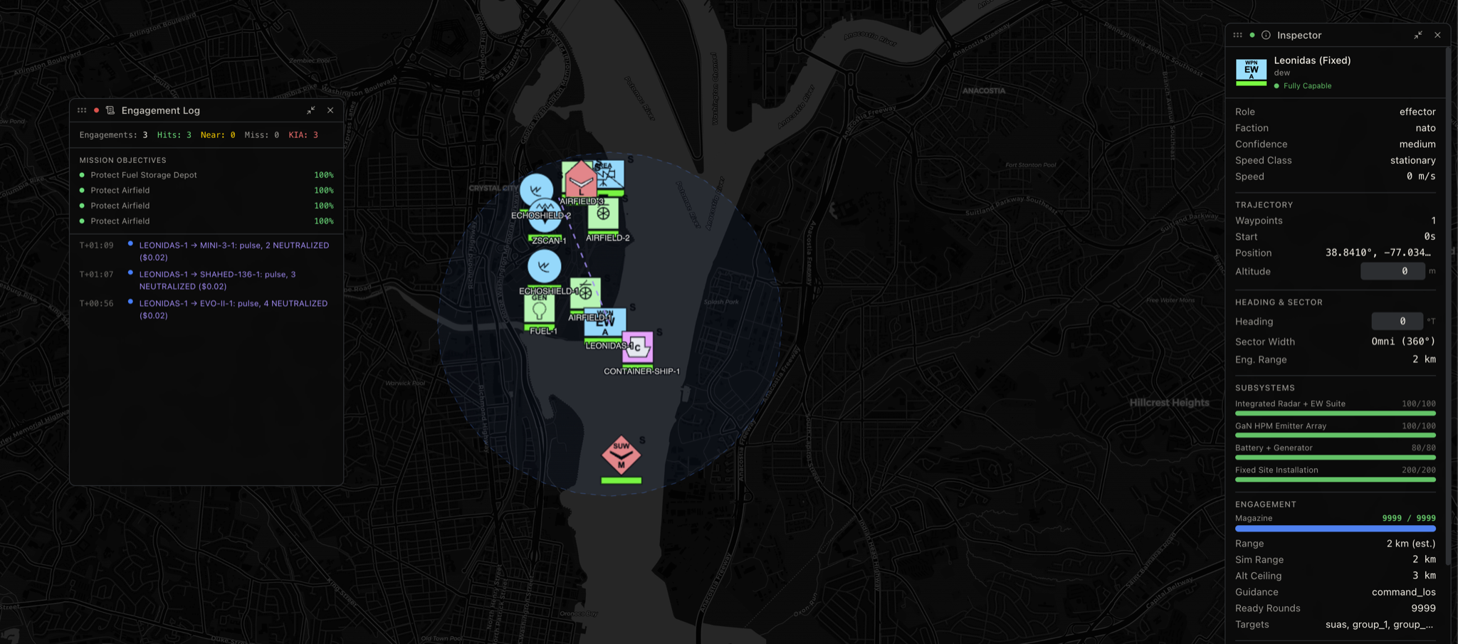
Kinetic: Projectile-Based Systems
When electronic and directed energy options are insufficient, unavailable, or unauthorized for your operating environment, projectile-based kinetic engagement is the traditional fallback. This ranges from small arms and crew-served weapons to purpose-built counter-UAS gun systems with specialized ammunition.
Engaging small UAS with conventional small arms is tempting in its simplicity and deeply challenging in practice. SUAS are small, fast, and maneuvering targets at ranges where even trained marksmen struggle to achieve hits with standard rifle ammunition. Shotguns improve the probability of hit at close range due to the pattern spread but are limited to extremely short engagement distances. While often used for its propagandistic and psychological effect, both Ukraine and Russia publish FPV strikes with glee against infantry dumping a full 30 round AK74 magazine at the threat to no avail.
Crew-served weapons like the M2 .50 caliber can engage at greater range but present significant collateral damage concerns from rounds that miss, and most rounds will miss. Even so, these are not brought to bear against traditional FPV and other SUAS threats but used from rotary wing assets against slower moving OWAs and ISR birds.
Where projectile-based C-UAS becomes more effective is with purpose-built ammunition and fire control systems. Smart airburst munitions like the Rheinmetall AHEAD system fire programmable rounds that detonate at a calculated distance and release a cloud of sub-projectiles in the target's path, dramatically increasing the probability of hit against small aerial targets. These systems require precise range data (typically from a dedicated fire control radar or LRF) to program the fuze, which ties directly back to your Sense and Make Sense architecture. Without an accurate range to target, airburst munitions are just expensive noise.
For your COP platforms, even if they support COAs, they need to consider the ballistics of these munitions within the effector engagement geometry. You'd need millisecond or microsecond resolution while tracking the target, which is the same problem space with cueing HEL effectors.
The overarching contraindication for all projectile-based systems is what goes up must come down. Rounds that miss the target (against SUAS, most will) continue their ballistic trajectory and impact somewhere downrange. In CONUS and urban environments, this creates unacceptable risk to civilian life and property for all but the most controlled engagement scenarios. Even in military environments, the fragmentation and unexploded ordnance (UXO) risk from C-UAS engagements must be weighed against the threat posed by the drone itself. Not every UAS justifies a kinetic response, nor is it a kinetic response realistic for all classes of UAS.
Kinetic: Interceptor Systems
Interceptor-based kinetic systems use either purpose-built counter-drone munitions or other UAS to physically engage and neutralize adversarial drones. This category spans from guided missiles to the drone-on-drone net-capture systems that represent one of the more innovative approaches to the C-UAS problem.
Missile and Guided Munitions
Missile and Guided Munitions systems such as the Coyote Block 2+ and similar platforms are designed specifically for the C-UAS role. They offer high probability of kill, engagement ranges measured in kilometers, and the ability to engage maneuvering targets. They offer far favorable effector geometry and longer maximum effective ranges than EW, DEW, and gun-based systems.
The contraindication is cost asymmetry, the defining economic challenge of modern C-UAS. When a $100K-$200K guided missile is used to engage a $500 FPV drone, the economics favor the attacker. Against higher-value threat UAS (armed reconnaissance platforms, large OWA drones), the cost exchange is more favorable, but against the volume threat of cheap disposable drones, missile-based interceptors are economically unsustainable as a primary effector.
At the current rates of production and the cost basis of even the most cost-effective Counter-UAS guided missiles, you will never be able to sustain the magazine-depth against a persistent peer-threat. You don't have to look further than Epic Fury.
Despite overwhelming US and Israeli air superiority over mainland Iran, slow first-gen OWAs continually bypassed some of the most sophisticated and densest AAD deployments and despite near-total intercept rates, the sheer cost of defending against hundreds of relatively cheap OWAs demonstrated the unsustainability of missile-based defense at scale. Weapons like the Coyote Block 2+ and other munitions may lower the cost asymmetry and expand engagement durations, but never at the speed or cost we want (need) it to.
Drone-on-Drone Interceptors
Drone-on-Drone Interceptors such as the Fortem DroneHunter and the XTEND Scorpio 1000 with the ParaZero DefendAir net-capture system represent a different approach to kinetic engagement. These systems autonomously detect, track, pursue, and physically capture adversarial drones using deployed nets. Besides the reduction of collateral damage, perhaps the most lucrative benefit is the potential to recover captured drones intact for forensic exploitation and FISINT.
This makes drone interceptors particularly attractive for environments where explosive or projectile-based engagement is prohibited or creates unacceptable risk: urban areas, airports, correctional facilities, and other CONUS critical infrastructure. There is also another class of interceptor drone that physically crashes into drones such as the Anduril Anvil (not be confused with its explosive cousin, the Anvil-M). This of course will (hopefully) destroy the target but makes live exploitation a bit more difficult due to the damage.
The contraindications for drone interceptors are engagement capacity, speed & endurance limitations, weather sensitivity, and high-confidence sensor fusion requirements. Whether it's a drone carrying a net, or a drone-as-an-interceptor, you have exactly one chance to get it right. Interceptors are typically SUAS, catching an 80-knot OWA or other lithe fixed wing airframes can work itself out to be an impossible engagement. While kinetic interceptor drones like the Anvil are designed for speed, they can only sustain that for so long and have a reduced maximum engagement distance.
Like with almost every other drone on the planet, you are impacted by weather, not just at the sensor-level. The weather may not be so inclement that you cannot fly, but a gust of wind or heavy rain or ice on your net will greatly reduce the chances of a successful deployment.
Finally, the requirement for high-confidence sensor fusion to provide targeting data cannot be understated. If your PID is wrong, you just sent a $50K interceptor after a bird. These systems also create their own IFF challenge; your interceptor drone is now flying in the same airspace as the threat, and your other C-UAS sensors and effectors need to know not to engage it. This ties directly back to the fratricide-prevention requirements we discussed in UAS-as-a-Sensor. Sensor Fusion systems without strong Multi Hypothesis Testing (MHT) and identity provenance corroboration may end up presenting your own drones as valid targets.
Kinetic: Explosive and Fragmentation
At the highest end of the escalation ladder are explosive and fragmentation-based systems that destroy threat UAS through blast effect or fragmentation patterns. This includes repurposed C-RAM systems like Phalanx CIWS and its land-based variants, proximity-fuzed ammunition fired from conventional air defense systems, and dedicated C-UAS munitions designed for area effect.
These systems offer the highest single-shot probability of kill and the ability to engage multiple targets in rapid succession (systems like Phalanx can cycle engagement quickly due to their high rate of fire and automated fire control). However, they also represent the maximum collateral damage risk. Fragmentation from burst munitions, unexploded ordnance from missed rounds, and blast effects all create danger zones around the engagement area. The sound signature alone from a C-RAM burst can create panic in populated areas.
In active combat zones, these tradeoffs are accepted because the alternative - allowing an OWA drone to reach its target - is much worse. In CONUS and peacetime environments, explosive C-UAS engagement is essentially a last resort reserved for imminent threat-to-life scenarios. The legal, regulatory, and public relations consequences of firing a burst of 20mm at a drone over a populated area are severe even if the engagement is successful. Let alone firing an IRIS-T or a PAC3-MSE at one.
While high caliber CIWS/C-RAM systems keep the cost asymmetry curve down low, it should be said that traditional GBAD should not be used for OWAs and other drone threats. Obviously, I don't think anyone would shoot an EKV interceptor at a DJI Phantom or Matrice 600, but they do shoot them at Shahed's and Geran's!
Emergent Solutions: Acoustic
Acoustic countermeasures is an emerging effector class. There's some early-stage work on using focused sound to disrupt MEMS gyroscopes in UAS IMUs. It's not operationally deployed anywhere I'm aware of, but some of the research is truly promising to offer another Direct Energy Weapon (DEW) that does not seem to have many countermeasures against it.
Fractal offers the Acoustic Resonance Mitigation (ARM), quoted directly from the above hyperlinked article as: "ARM disrupts drone flight by emitting sonic, ultrasonic, and subsonic waves that induce vibrations or Prandtl layer instability, ultimately leading to flight failure. Propeller blades, in particular, are highly susceptible to ARM's effects, either through increased turbulence or by transferring destabilizing vibrations to the drone's inertial measurement unit (IMU), compromising its ability to maintain stability."
The physics for this one really tickles the brain, and we look forward to modeling this capability in our cyber range.
Operator Interdiction
The most overlooked Act capability, and one of the most effective for CONUS and law enforcement contexts is going after the human, not the drone. If your Sense and Make Sense architecture can identify the operator's location through RF direction finding, Remote ID operator location broadcasts, SIGINT geolocation, OSINT correlation, or your own airborne ISR: dispatching a response team to interdict the operator can end the threat at its source.
Operator interdiction has several advantages over engaging the drone itself. It removes the threat at the source rather than one airframe at a time. If the operator(s) have multiple drones or the ability to launch follow-on sorties, interdicting the operators stops all the UAS threats. Interdiction enables evidence collection and prosecution rather than just neutralization. It avoids the collateral damage concerns of kinetic or electronic engagement. And it is generally within the legal authority of law enforcement agencies that lack C-UAS-specific authorities.
The contraindications are time and distance. If the operator is 5km away and behind terrain, and the drone is 30 seconds from your defended asset, operator interdiction is not going to solve your immediate problem. This is a complementary capability that works best when combined with other effectors that buy time, such as soft-kill effects that trigger RTH or hover-in-place while your response team converges on the operator's location. The HUMINT and OSINT capabilities we discussed in Sense feed directly into this: social media posts, LAANC cross-referencing, and community tips can all vector a response team before or after the drone event itself.
The Layered Defense Imperative
No single effector answers every C-UAS threat. A layered defense architecture that matches effectors to threat profiles, engagement zones, and ROE constraints is the only approach that works across the full spectrum of UAS threats. Your layered defense should map directly to the defense-in-depth concept from Deployment Considerations, though with more mindfulness to effective ranges balanced against optimal engagement envelopes and minimize collateral damage.
The selection of effectors for each layer must account for the threat's characteristics (size, speed, autonomy level, payload), the operating environment (urban vs. austere, CONUS vs. OCONUS, civilian presence), the legal authorities available to the defending organization, and the economic sustainability of the chosen effectors against the expected threat volume. A $200K missile defending against $500 drones is not sustainable. A $50 burst of smart airburst ammunition might be. A directed energy engagement that costs pennies per shot definitely is, if the system is available and the physics support the engagement.
This is where the entire Sense-Make Sense-Act continuum comes together. Your sensors detect the threat early. Your fusion engine classifies it and generates physics-informed COAs. Your policy engine matches the classified threat against available effectors, ROE, and engagement constraints. And your operator, supported by a COP that compresses the decision cycle rather than expanding it, executes the chosen COA with confidence that the recommendation is grounded in physics, and not gpt-oss-120b.
Every component of the chain depends on every other component. A world-class sensor network is useless without fusion. Fusion is useless without a COP that enables timely decisions. And the best effectors in the world are useless if they are cued too late, pointed at the wrong target, or unauthorized for the engagement.
Conclusion
If you've made it this far, thank you! A lot of research and work went into this, and we appreciate anyone who takes the time out of their day to read nearly 18000 words worth of doctrinal and operational knowledge!
In this blog we covered the Counter-UAS problem space in great depth across the full Sense-Make Sense-Act Joint All Domain Command and Control (JADC2) continuum to include both sensor, effector, and sustained Deployment considerations. We covered down on eight Sensor modalities including their strengths, limitations, and contraindications.
Additionally, we covered in detail the different Deployment considerations for the modes of deployment, coverage, dealing with operational and environmental issues, as well as contingency planning and logistics support. We went deep into "Make Sense" including data normalization and sensor fusion issues, building better Common Operating Pictures (COPs), and supplemental capabilities from slewing LRFs to physics-backed COAs for physical and electromagnetic effectors.
Finally, we went over nearly every type of option you can have (within the correct legal and regulatory frameworks) for "Act" from passive effects, soft kill, EW, and kinetic options and some emergent capabilities. This included contraindications and considerations as well as deployment considerations specific to effectors.
We sincerely hope this helps you whether you're a vendor, a customer, a prospect, or just someone curious about where to start your Counter-UAS journey or looking to improve. For the vendors out there for sensors and effectors: we'd love to partner with you to combine our Joint All-Domain Operations (JADO) sensor fusion and wargaming platform with your sensors and/or effectors. If you run Counter-UAS operations, regardless of your industry and want to see how our simulation or sensor fusion can help you, we'd love to give you a demo and talk more. Both partners and interested buyers can reach us with this form.
And to everyone else, again, thank you for your time!
Stay Dangerous.
