Introduction
I'm not a space force guy, nor will I ever be, and neither am I an astrophysicist - but I pretend to be on the weekend. Empyrean Defense is leaning hard into the space domain anyway and so should you. There are space domain challenges and threats that are self-contained, as well as those that can impact everyone from UAS pilots to site security specialists to electromagnetic spectrum operations.
While it might be hard to rationalize the space domain given the doctrinal and physical scope, we've all been impacted by it. Whether it's degradation of navigational aids, spurious emissions we just couldn't explain, or embarrassing influence operations borne from peer threats publishing satellite imagery of otherwise classified events. Just because it’s a domain that holds an asymmetrical effects advantage (across all domains) against us, doesn’t mean we cannot be prepared for it.
In this blog we'll dive deep into the doctrine (and some math) as told by someone who doesn't want to lecture or scare you. You'll learn about the doctrine of Space Situational Awareness (SSA) and Space Domain Awareness (SDA) in detail, and the threats and considerations therein. Next, you will learn about the cross-cutting effects that the space domain can take across all other domains. Finally, you will learn what you can do to mitigate these threats and then close the blog out with final thoughts.
Before we get into this, fair warning; this piece will lean more towards military-specific use cases and jargon throughout. If you’re running physical security or site operations for any state, local, tribal, or federal agency or if you’re solely on the commercial side: this applies to you too! A satellite taking pictures of an air defense battery will happily take pictures of your data center, airfield, energy production facility, office park, or otherwise - and that ISR information could be used against you too.
Space Domain Doctrine
The United States Space Force (USSF) has plenty of doctrinal writing about the space domain, and the United States Air Force Space Command (AFSPC) had plenty in the past too. As we already established, I’m just a Defense software guy obsessed with the domain and not a formal practitioner; we’ll focus on the two that matter: Space Situational Awareness (SSA) - and its parent - Space Domain Awareness (SDA).
Space Situational Awareness
SSA, despite some conflation of terminology, is subordinate to SDA. In Space Domain Publication (SDP) 3-100: Space Domain Awareness_pdf_safe.pdf) from November 2023, SSA is defined as “The requisite foundational, current, and predictive knowledge and characterization of space orbital objects and the space domain.” This description is in turn lifted out of Joint Publication (JP) 3-14, Joint Space Operations from January 2009. Really, SSA revolves around baseline understanding of “what is out there” in space. This is simply the “Sense” part of Joint All Domain Command and Control (JADC2) for the space environment.
What is the space environment? Glad you asked. SDP 3-100 defines it as: “... the natural operating environment, space debris, threats, adversary use of space, and commercial space.” So, it’s not just understanding what satellites are above, it’s also defunct payloads and debris that can damage or destroy them, extraterrestrial weather patterns which can degrade observations and/or flight propagation, and overt threatening activity which we’ll cover later.
This brings us to the second part of the definition of SSA via SDP 3-100, regarding how we put this knowledge together, which is: “That knowledge is developed through the collection of data primarily by the SSN, a combination of sensors used to detect, track, and identify resident space objects (both natural and human made).” The SSN in this case refers to the Space Surveillance Network which is a very military definition of what I referred to: academic, military, and open-source sensors and observers that provide us with the Situational Awareness (SA).
The way that we conduct SSA is through a combined use of military and commercial ground-based and space-based sensors, as well as very well-established astrophysics which allow us to calculate the positioning of satellites and debris, their speeds, where they’ll go next, and the confidence around that information. That is what undergirds the SSN but also extends to other information such as space weather and other naturally occurring phenomena like Coronal Mass Ejections (CMEs), closely related to solar flares.
Furthermore, we can even understand things such as the inclination angle to determine what the satellite can “see” and the apogee, as well as other space domain specific Position Location Information (PLI) and kinematics. This flows into SDA and allows us to map ground tracks in 2D space on a Geospatial Information System (GIS) map. Likewise, it also lets us understand when and where we can observe a space system and vice versa. The way that most of the industry - and indeed us at Empyrean Defense - accomplish this is via SGP4 (Simplified General Perturbations-4) and SDP4 (Simplified Deep Space Perturbations-4) which are both types of analytical orbit propagation models.
The input to these formulas is the Two-Line Element, commonly referred to as the TLE. For those curious, TLEs used to be made on two, 80-column punch cards, which is where the name comes from. Modern TLEs are provided via data providers such as Space-Track, Celestrak, and others by way of NORAD and NASA. Since we’re in the modern era, this data is provided in machine-consumable formats such as XML and JSON, with the mathematics available in the open-domain as software packages to consume them. TLEs do exhibit decay over time, they lose around 1-3 km of accuracy per day, and generally you want to avoid re-use after a week after the epoch (the day the TLE was generated) to avoid mathematical anomalies that will show up as impossible travel speeds or orbit regimes.
Doctrine is easier to digest with something tangible, so let's use the International Space Station. It's one of the most-observed objects in orbit, and anyone can pull a fresh TLE for it off Celestrak in about ten seconds. A typical ISS TLE looks like this:
ISS (ZARYA) 1 25544U 98067A 26108.50000000 .00016717 00000-0 10270-3 0 9993 2
25544 51.6400 123.4567 0007890 90.1234 270.1234 15.49000000000000
Those two lines encode everything SGP4 needs to project where the ISS will be, when. The fields are positional (column-delimited, not space-delimited - a common gotcha) and include:
- NORAD catalog ID (25544)
- Epoch (year and fractional day the TLE was generated)
- Inclination angle (51.64° - which is why the ISS ground track sweeps between roughly 52°N and 52°S latitude and never reaches the poles)
- Eccentricity (near zero - nearly circular)
- and Mean Motion (~15.49 revolutions per day, or roughly one orbit every 93 minutes).
Feed those values into SGP4 and you get position and velocity in a TEME (True Equator, Mean Equinox) reference frame, which you then convert to whatever frame you want to plot on - typically ECEF for a ground track on a GIS map. Operationally, that translates to: I can tell you the ISS is about 420 km up, I can tell you when it will be over Kandahar or Kyiv or Guam down to the second, and I can tell you what portion of the Earth's surface it can see from that altitude. All from two lines of text that look like someone passed out drunk on the keyboard. That's the power of SSA at its most basic: open-source data, well-established math, and a map (or a globe).
SSA doesn't stop at the NORAD catalog. To get a useful picture you also pull from the International Telecommunication Union (ITU) for filed frequency allocations, from commercial SSA providers like LeoLabs for higher-cadence tracks on objects the public catalog is slow to update, from payload databases like the UCS Satellite Database for what a given bird is supposed to do, and from NOAA's Space Weather Prediction Center for the environmental conditions that affect both the birds and the radio paths to and from them.
That's a lot of data and stitching it together into something coherent is its own data engineering problem - but it's all still SSA. If you would suffer a sales pitch for a second, that data engineering problem is one of many reasons we founded Empyrean Defense. It’s also one of the reasons we aren’t pulling our hair out anymore. Coming from petabyte-scale cybersecurity analytics into the relatively manageable volumes of space data is also a nice quality-of-life upgrade. That said, most of the data is still atrocious, and when you’re building a sensor-fusing decision layer that is also a data fabric - those skills come in handy.
All SSA is "what is out there and where." Here's the catch: SSA can tell you an object is at position X with orbital parameters Y. It cannot tell you:
- What the payload is actually doing right now (the ITU filing says "Earth observation," but is it imaging, or is it co-hosted with a SIGINT payload, or was it re-tasked two years ago?)
- Whether an observed maneuver was routine station-keeping or something with intent behind it
- Who actually controls the bird at this moment - ownership changes, leased capacity, and co-hosted foreign payloads are a real thing.
- What a pattern of life means when you overlay it against terrestrial events.
- Whether the catalog entry is accurate, or the operator is deliberately running quiet.
Every one of those questions is something an operator needs answered before they can act on the space picture. And none of them can be answered with astrophysics and some SQL joins alone. That's where Space Domain Awareness comes in.
Author’s Note: This wasn’t even close to being exhaustive for SSA! There are entire specialized weather considerations as well as the ground infrastructure that supports the space domain: ground stations, launch sites, space logistics, and other intelligence disciplines that support finding birds that don’t want to be seen and tracking pre-warning indicators for launches.
Space Domain Awareness
By now, you’re a veritable astrophysicist and SSA expert, right? Now you need to take your fully enriched catalog and notebook full of math calculations and contextualize and corroborate it against other activities in the space domain, and across other domains. SDP 3-100 quotes JP 3-14 and defines SDA as: "The timely, relevant, and actionable understanding of the operational environment that allows military forces to plan, integrate, execute, and assess Space operations."
Military-specific parlance aside the translation is: SSA is the catalog and physics; SDA is the meaning. SSA tells you what is there. SDA tells you who it belongs to, what it's doing, what it's likely to do next, and whether you should care right now. If SSA is the "Sense" part of JADC2 for the space domain, SDA is the "Make Sense" part - characterization, behavioral analysis, intent inference, and the correlation of all of it with activity in the other domains.
Not to discount the military perspective, as Empyrean is a dual-use platform we take a more holistic approach to this, adversarial behavior at a geostrategic level can impact us even if we’re not the primary target of animus or geopolitics. Said simpler, motive may not be as important as what are the real potential impacts and what can we do to prepare for it. SDP 3-100 goes into (great) detail about the military perspective on SDA and focuses on the space domain properly as well as the electromagnetic domain as a tightly coupled second-order domain, and so should we.
The first thing we need to figure out in SDA is characterization. This is the practice of matching a tracked object to a payload type, a mission purpose, an operator, and a behavior profile. This is where ITU filings, commercial payload databases, RF signature analysis, and optical observation get fused into an identity that's more than a catalog number. It’s the difference between knowing a NORAD catalog ID is at a specific position in orbit versus knowing that a Chinese imagery satellite that downlinks on UHF and X-Band frequencies with a certain revisit regime, and if the revisits get longer while it orbits in a meaningful way.
I provided some resources you can use for this analysis in the SSA section, and once your data is hammered out in a cogent and normalized fashion, you’re only a SQL materialized view or a few joins away from doing this. However, it’s not a point-in-time practice; it is a continuous process that cannot be solved solely by retrieving historic TLEs (though that can and will help). This splits into two equally important paths, building a pattern of life, and detecting maneuvers.
Pattern-of-life and maneuver detection tend to go together but are solved in different ways. At the end of the day every satellite has a rhythm: station-keeping burns, attitude adjustments, seasonal drag compensation, and/or reacting to space weather. SGP4 projections will drift against reality when a satellite maneuvers, and that drift is the tell. An anomalous maneuver - one that doesn't match the historical pattern, or the bird's stated mission can be a red flag. Whether that maneuvering is overtly suspicious (or malicious) is what Pattern-of-Life enables you to ascertain.
Satellites maneuver all the time; it is why understanding debris fields is just as important as understanding where the payloads are. Building our own conjunctions or consuming them from an authoritative specialist source can help figure that out. It shouldn’t be taken as malicious intent for any operator to want to prevent their bird from being struck, even if that bird is operated by an adversarial country in a geostrategic sense. This goes a long way in ensuring continuous and safe access to space for all humanity.
That said, if an orbit regime straight up changes (very extreme case) or the orbital mechanics meaningfully change epoch-over-epoch, that is more alarming. A satellite reportedly carrying scientific experimentation payloads that starts station-keeping or elongating passes over a sensitive area - such as military base or critical infrastructure site - could certainly be suspicious. That could denote a change in mission profile, dual-use technology, or the reported technology was false. If there is transmission data to go along with the satellite and the electromagnetic activity on downlink is also meaningfully increasing, that goes further to explaining possible motive.
Another way to think about it is if your neighbor starts setting motion lights up around their house to go with their new security system, that isn’t such a bad thing. Then they start switching out from motion-triggered to persistent lights. Then a few weeks later they start reorienting the lights closer to the property line - even then - it's not suspicious; they could be looking for raccoons, foxes, or coyotes who may be causing damage. They may even tell you as much and announce it on their social media. Then a few weeks later the cameras are pointing towards your car, then your driveway, followed by the lights starting to track you when you leave the house.
It could be a coincidence at first; a misconfiguration could explain it too, but it requires further investigation. Peer threats in space aren’t your weird neighbor: they’re not going to tell you, and they won’t make it so obvious either if they’re good, SDA requires diligence and big data engineering prowess.
As far as specifics within maneuvering go, Rendezvous and Proximity Operations (RPOs) are an observable version of the type of movement that could be overtly malicious or overtly benign depending on the pattern of life and other corroborating elements. When a satellite closes with another satellite, this can be for an inspection or repair. In some cases, it can be for towing - like when Shijian-21 towed the defunct BeiDou-2 G2 GEO into a graveyard orbit above GEO (Geostationary Earth Orbit, ~35,786 kilometers (~22,236 miles) above Earth's equator).
The same equipment that can support repairs and towing can also support RPOs used for more threatening outcomes such as “yoinking” a satellite, damaging shielding or electronics, or launching space-based effectors or employing Directed Energy Weapons. Don’t just take my word for it either; RPO and Seizure have been written about in space domain communities for a few years, such as this 2021 article from National Defense by Mandy Mayfield on the topic.
DEWs such as High-Energy Lasers (HELs) do not only exist for anti-ballistic and counter-drone mechanisms; they can also be used to degrade, damage, or destroy other satellites. The lasers can do material damage, with much lower extinction rates against the beam in space leading to strong effects. If outright destruction isn’t the goal, overwhelming the sensors can cause outages for hours or even days. While this is technically cross-domain, ground based HELs such as Russia’s Peresvet HEL) can use the same SSA and SDA dynamics to figure out space targeting information and dazzle from the ground.
When used for purely space-domain offense, weapons are considered Anti-Satellite (ASAT) or Counterspace weapons. This Space Threat Assessment 2025 from CSIS goes into greater detail on the topic, as have previous publications going back to 2018 (the farthest back I have read). Our previous examples are not exhaustive either, you can imagine in 2038 instead of watching FPV drone footage targeting unfortunate infantrymen there could be some form of space based Remotely Piloted Vehicle (RPV) used for targeting satellites. The demoralization and propagandistic effects in the information domain would be catastrophic but so too would the actual physical effects.
This gets us into the Environmental portion of SDA. Space debris, Coronal Mass Ejections (CMEs), geomagnetic storms, and atmospheric drag variations aren't threatening in the adversarial sense, but they're considered threats in the operational sense. A strong CME can degrade GPS signals, induce errors in satellite electronics, and expand the upper atmosphere enough to change the drag profile of everything in Low Earth Orbit (LEO). SDA must weigh these the same way a ground commander weighs weather. This ties back into establishing motive, but there are second-order environmental effects because of adversary actions in space.
Kessler Syndrome is an often-misused term that comes from [Collision frequency of artificial satellites: The creation of a debris belt](https://in the Journal of Geophysical Research) published by Donald J. Kessler (a researcher in NASA’s Environmental Effects Office at Johnson Space Center) and Burton Cour-Palais in the Journal of Geophysical Research in 1978. The article cites several preceding sources from the 1960s and 1970s that used mathematical models to theorize that over the course of decades, or even centuries, debris fields from satellites and other payloads could intensify around the Earth’s orbit. While it may not (read: likely wouldn’t) be in the timescale of a Hollywood thriller, nor “lock humanity out” of space, the threat is real.
That said, even with the testing of direct-ascent ASAT weapons by the US, India, China, and Russia - along with a myriad of other accidental or micrometeorite collisions, agencies on Earth do a fantastic job of cataloguing and tracking debris. That translates directly into benefits for SSA and wider SDA, and regardless of adversarial intent, it serves no nation any good to completely rule over a hegemonic trash heap above Earth’s atmosphere. Additionally, damages in Low Earth Orbit (LEO) will be slowly dragged down into Earth’s atmosphere and burnt up. While this can cause hazards such as pieces of the space station hitting a home in Naples, Florida in 2024, it’s far more hazardous in higher orbits. Although obviously the higher the orbital regime the wider the ellipsoidal area, the overall risk is much lower given the vastness of space to cover.
Author’s Note: For a much more in-depth analysis on environmental effects in space, the 2024 article Understanding the misunderstood Kessler Syndrome from Aerospace America by Jon Kelvey is a fantastic read. Suffice to say, tracking debris is just as important to your overall SSA and SDA mission as tracking the satellites themselves.
Once you have SDA, the space picture stops being an astronomy exercise and starts being an operational input - which is where it collides with everyone else's problem set. While several other domains like ground, electromagnetic, and information are used to curate intelligence to carry out SSA and SDA - the space domain can also impact those domains and several more. Integrating space-domain awareness into your common operational picture is what turns pass windows and orbital tracks into actionable warnings for the people on the ground.
How the Space Domain Manifests Across Other Domains
On April 19, 2026, Chinese commercial imagery providers - reportedly including MizarVision - published annotated satellite photography of repositioned US THAAD and Patriot batteries inside Jordan during the fragile US-Iran ceasefire. The launchers, radars, and support vehicles were identifiable down to system-level components. The imagery came from commercial providers, not classified Chinese military reconnaissance, which is the strategically significant part: the baseline commercial capability is already sufficient to expose CONOPS-level movements in near-real-time. That's the "so what?" question I usually get answered for me by the news cycle.
This is particularly important to note, because it was not a onetime thing, several times during the duration of Operation Epic Fury I saw battle damage assessments (BDAs) driven by commercial Chinese imagery satellites showing damages to everything from THAAD TPY-2 radars to the AN/FPS-132 “Eye of the Desert” done by IRGC ballistic missile and One-Way Attack (OWA) drone operators. This is a clear case of the space domain impacting other domains, in this case the ground domain in relation to U.S. Ballistic Missile Defense (BMD) batteries.
Author’s Note: These incidents are panned in greater detail in this 20 APR 2026 article in Breaking Defense by Casey Laughman interviewing Tom Karako, director of the Missile Defense Project at the Center for Strategic and International Studies (CSIS). I would also recommend following more adversarial (to the U.S.) telegram channels such as Tabz - Alternative Media, Middle East Spector - MES, and Fotros Resistance. This is not an endorsement or anything other than a potential research avenue to see developments in near real-time play out across the information domain not dominated by major mainstream outlets.
These are just a few concrete incidents of many that happened during Epic Fury, which pales in comparison to just how often this happens, and we’re going to explore some more in detail.
Space Domain Effects in the Electromagnetic Domain
Besides imagery satellites overflying the THAAD you have parked in your driveway; there are more subtle cross-domain effects from space that impact us. The electromagnetic domain impacts have second order effects that flow through to terrestrial domains (Air, Ground, Maritime) as well, but that’s for another section. The electromagnetic (EM) domain impacts from space are typically from space-based Electronic Warfare (EW) and Signals Intelligence (SIGINT)/Electronic Intelligence (ELINT) space platforms and from spurious emissions during flyovers from the uplink/downlink packages of satellites.
Aside from sophisticated laser-based communications systems, almost every single satellite uses radio frequency (RF) to communicate with their ground stations and other satellites from space. Typically, these run from the lower-end of UHF (300 MHz - 3 GHz) all the way through Ka-band and Ku-band, and in some cases even higher. You’ll see all sorts of bands represented - depending on your enrichment sources - such as L-Band, S-Band, X-Band, and more!
The strength of these transmissions varies, and there are entire projects dedicated to crowdsourcing and tracking these transmitters such as the SatNOGS project though ITU, as previously mentioned, is a much more authoritative source - albeit the ITU doesn’t key satellites by their NORAD ID - so you need some clever data engineering finesse for joining that data.
Regarding EW, ELINT, and SIGINT, these are typically classified payloads (for obvious reasons) and are well within the realm of military usage. I cannot say with any confidence that a space-based Electronic Attack (EA) platform exists - the physics of Inverse Square Law and other atmospheric attenuation would suggest that’s nearly impossible - but there are birds with these payloads who can and will listen. As to what they listen to, that is also unknowable, but as a former comms guy it’s not lost on me that adversary classified payloads would be listening on well-known Cooperative Engagement Capabilities (CEC) related channels. While they may not be able to home in on the hopping subchannels, they’re almost certainly listening to FHSS L-Band Link 16 and otherwise, not all transmission belies action, but it certainly belies presence. As far as your DMR radios used at your factory or shipyard? I’d wager it matters very little.
As far as the uplink and downlink channels impact on other things in the EM domain, that is where it gets interesting. That Inverse Square Law is just as brutal coming through the atmosphere and ionosphere from 500 km above the Earth’s crust (for LEO satellites), so I am not suggesting your Software Defined Radio (SDR) frontend or radar is going to be toast, but what these spurious transmissions can do is raise your noise floor. If you're running a sensitive DSP array or an EW receiver designed to pick up weak signals, even modest in-band energy from a downlink pass raises your noise floor and degrades your detection sensitivity for the duration of that pass. Multiply noise floor elevation happening X times across a constellation of Y satellites with overlapping passes, and it becomes a persistent degradation rather than an event.
Even using something that is “medium-grade” like a Nuand BladeRF 2.0, using our own Electromagnetic Spectrum Operations (EMSO) Signal Groups and Electronic Order of Battle features that coincides with our Space Situational Awareness (SSA) module, I’ve picked up and corroborated space-based downlink on a frequency. While it didn’t stop me from building intelligence on my electromagnetic environment, it would’ve certainly screwed up our Digital Signal Processing (DSP) ability to discern cyclostationarity, hopping, and bursting patterns in the SigMF file.
For Positioning, Navigation, and Timing (PNT) - such as GPS, GNSS, GLONASS, etc. - the attack vector is mostly ground-to-space (jamming, spoofing), but the dependency is space-to-ground. GNSS is a space asset whether the threat originates in space or not. To provide wide coverage, PNT satellites are typically stationed in Medium Earth Orbit (MEO) at an altitude of ~20,200 km (~12,550 miles) from Earth and transmit on specific GPS Bands, the three typical civilian frequency bands are located in the L-band spectrum: L1 (1575.42 MHz), L2 (1227.60 MHz), and L5 (1176.45 MHz). These are well-known, sensitive to jamming, but also sensitive to space weather.
A Russian Krasukha-4 EW node can be just as devastating to PNT/GPS as space weather, which is a much more salient threat especially for CONUS and commercial operations than broadband GPS jamming and spoofing. CMEs, solar flares, and subsequent ionospheric scintillation from a geomagnetic storm degrades GPS accuracy without any adversary spending a dime. This is purely a space-based threat, but there is nothing you can do to prevent it other than plan - which we will cover in the final section of this blog (hint: PACE planning!).
Cascading Space Effects on Ground, Maritime, and Air Domains
In the previous subsection, we concentrated solely on electromagnetic (EM) domain effects and mentioned there are subsequent second-order effects from it, which we will cover here. PNT degradation has a large effect on everything from military use cases, commercial Counter-UAS, through to day-to-day life for citizens around the planet. Frequency Hopping radios, sensor geo-positioning data, Fire Control Systems (FCS), and even how we navigate to dear old grandma’s house in the prairie rely on PNT.
For instance, take the air and maritime domains and their cooperative sensors: Automatic Dependent Broadcast - Surveillance (ADS-B) and Automatic Identification System (AIS), respectively (there is also Universal Aircraft Tracking (UAT), that is mostly used in the U.S.). This is what powers the ability for aircraft and maritime vessels to be tracked (and technically other things but that’s neither here nor there) and powers secondary collision avoidance, airspace and waterway deconfliction, logistics, and several other important logistical tasks. These cooperative sensors are broadcasted on 161.975 MHz and 162.025 MHz (VHF maritime channels 87B and 88B) for AIS, 978 MHz for UAT, and 1090 MHz for ADS-B. Beyond Visual Line-of-Sight (BVLOS) these signals can drop off, which is more pronounced for surface vessels than aircraft.
There are a myriad number of vendors who provide satellite-based tracking of aircraft and surface vessels which also relies on PNT. While yes, there can be noise floor attenuation that disrupts tracking the signals themselves, in GPS denied environments you will have ship positions straight up missing, reported in vastly different positions, or adversaries can replay or spoof false targets. This makes waterways, tracking of sanctioned vessels or cargo, and general situational awareness much more difficult if not impossible for these systems who take cooperative identification at its face value. For an example of this, check out this recent (as of the time of this writing) BBC article GPS jamming: The invisible battle in the Middle East by Chris Baraniuk from 9 MAR 2026.
More than logistics-based situational awareness, there are also whole sensor classes that greatly rely on PNT to establish their position and report the position of tracks. This goes double for on-the-move platforms such as a RF direction finding (RFDF) array mounted onto a buggy, or a radar mounted on a truck. Even for stationary positions that rely on intermittent GPS checks to understand its position, having your sensor position drift by even a few meters means having an unreliable target tracking capability which will only be exacerbated the further a target is away from your sensor. A degraded sensor is in some cases worse than one taken offline, now you have to contend with not being able to trust your highly accurate, non-cooperative sensor that thinks it’s in another location and the target it is tracking is reported a kilometer farther than what it was.
One of the more immediately operationally impactful cases of PNT degradation is with unmanned aerial systems (UAS), and really any autonomous or unmanned system, be they ground, surface, or subsurface vehicles. In all commercial SUAS in the US, losing GPS of the asset forces a landing or Return to Home (RTH) feature. Even systems that can be resilient to this due to Inertial Navigation Systems (INS) can have degraded mission accuracy (especially when flying automated routes).
Speaking of INS, pretty much every modern guided munition, be it a GBU-31 JDAM, a Russian FAB-1500 UMPK, a Tomahawk Land Attack Cruise Missile, or any number of air defense anti-ballistic missile has GPS and INS guidance. While high precision long range fires may be harder to degrade with GPS denial, in several 100 simulations of GPS-based jamming against FAB-series UMPK glide bombs, we could move the bomb by several dozens of meters which can mean the difference between successfully prosecuting a target, and striking a civilian home or logistics hub. Even if you are protecting yourself for GPS/INS-guided munitions, the second-order effects can be catastrophic (noticing a trend here?).
The ultimate destructive implementation of ground-effects on space platforms is the Direct Ascent Anti-Satellite (DA-ASAT) weapon. If a peer threat decided to target a Starlink constellation or even commercial imagery or GPS satellites, there could be catastrophic secondary effects following the vein of the “Kessler Syndrome” as detailed in the previous Space Domain Awareness (SDA) section. One of the most well-known incidents occurred in February 2009 when the defunct Russian Cosmos 2251 satellite collided with the United States’ Iridium 33 creating over 2500 pieces of trackable debris. Based on the analysis from the article The Day Two Satellites Hit Each Other at 26,000 MPH by Theodore Kruczek at KeepTrack, the force was equivalent to several 100s of kg of TNT, at least a GBU-28 Paveway’s worth, if not a full FAB-1500!
That was purely by accident, though you could attribute it to a SSA failure. A deliberate targeting of a constellation by several DA-ASATs or other space-based counterspace weapons could destroy or degrade the entire constellation. The physics modeling exists for this theoretical attack and then comes with the semi-permanent loss of PNT, communications, imagery, early warning, SIGINT/ELINT, or any other mission type. Rapid deployment of orbital payloads is a very cost-prohibitive and emerging capability. Regardless, an attack of this proportion most certainly would come alongside a devastating war, so let’s hope we don’t ever see kinetic counterspace weapons ever used in a conflict.
Space Domain Impacts in the Information Domain
Space-based ISR provides capabilities you cannot be aware of without strong SSA and SDA, and regardless, it’s not a capability you can consent to. Hundreds of known catalogued imagery satellites orbit around the Earth multiple times per day, a large sum belonging to scientific and commercial organizations. Aside from hiding or employing concealment or other misdirection techniques during a pass window, there is not much that can stop it other than thick cloud cover (also something you can plan around using, thanks to meteorological satellites!)
However, counter-surveillance is not what we’re talking about, it's the outsized effect of persistent and nigh-on unassailable ISR assets being able to provide ground truth within an orbit cycle, combined with station keeping and other orbital maneuver, they can even stick around a lot longer than welcomed. Not to keep yapping about Operation Epic Fury, but this is one of the most clearcut and well-documented examples of information domain impacts (at least in your humble author’s opinion).
It is already known that US commercial platforms such as Planet Labs put a freeze on imagery requests from the conflict zone, mostly the Gulf Coast Countries (GCC) which are home to the United States Navy 5th Fleet, CENTCOM, and several other assets ranging from signals and logistics, to BMD and other air defense batteries. In the opening days of the war, the satellites that were sticking around the longest that drew my attention was the Chinese Jilin constellation of commercial imagery satellites. All told, there are 43 satellites in the constellation according to the data we get from Space-Track, starting from JILIN 1 (NORAD 40961) and ending with JILIN-01 KUANFU 02B 6 (NORAD 61194). Based on the best open-source data we have access to regarding mission disposition; they’re all imagery satellites.
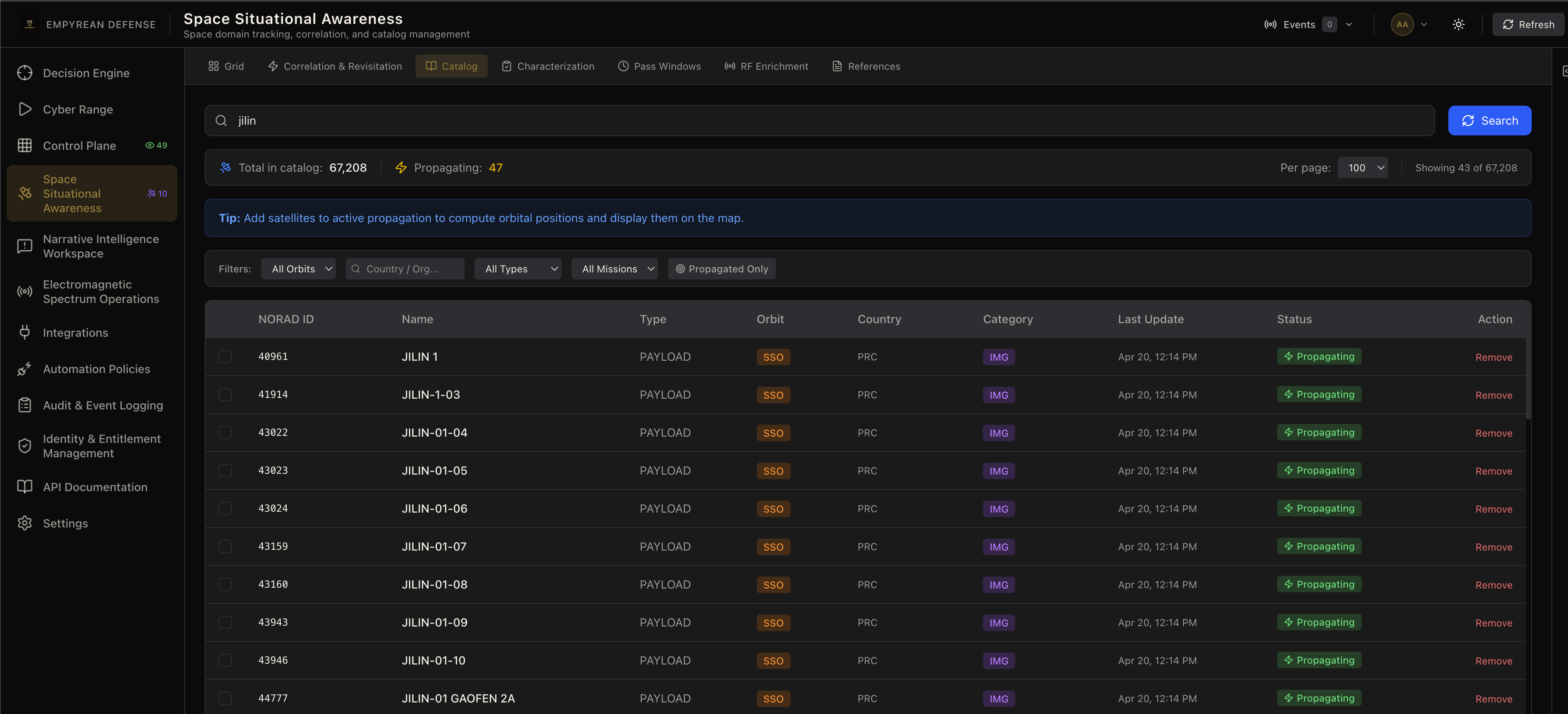
On Telegram, several anti-U.S. channels posted fully annotated Battle Damage Assessments (BDAs) from this constellations (and others like Mizar Vision) showing before and after shots of damaged or destroyed MIM-104 Patriot batteries and THAAD batteries, with damage to their radars, launchers, command & control videos, and several destroyed structures. The most jarring of all these images was the “Eye of the Desert” in Qatar, an AN/FPS-132 Block 5, one of the photos that circulated on Telegram before it hit the press can be seen in this article from the Military Watch Magazine from 10 APR 2026.
All this imagery was coming out as U.S.-based space firms such as Planet Labs were freezing availability of data from the Area of Operations (AO) for Operation Epic Fury, this was panned in several blogs and news articles such as this article from the Jerusalem Post in early April 2026. This makes perfect sense. Why let anyone in the world access what could be free targeting data for the IRGC missile corps? Of course, this took a twist on blogs, social media, and Telegram with the decision being lampooned as a poorly executed Public Affairs (PA) operations to “hide” the true scale of the damage done. What added further fuel to the fire - seemingly, in my humble opinion - was the CENTCOM PAO publishing “Fact Checks” throughout, some of which didn’t appear to be true.
Say what you will about the military capabilities, but in the information domain, Iran and its supporters - and anyone who is anti-U.S. or anti-Israeli, for whatever reasons - gladly shared the pictures and videos. This devolved into AI music videos featuring US and Israeli politicians, and live action Lego Movie styled shorts and rap music videos. Whimsical though they may be, I cannot help but think that the latter pieces of information warfare kit were intended to be consumed by kids and young adults, especially as they “broke containment” and ended up on Instagram, TikTok, and YouTube Shorts.
The reason I am detailing this is because it all started from a box with solar panels the size of a car 400-500 km above Earth. Also to note what it must have felt like for the families of servicemembers forward deployed, and the servicemembers themselves, to see this all unfold in real time. You’ve been up for several nights, you likely haven’t showered, your base has been getting hit, there are ballistic missiles, hypersonic MaRVs, OWA Drones, loitering munitions, and more flying overhead - region-wide.
It is probably a terrifying thing, especially when AI-modified or AI-generated versions of the pictures started coming out as part of a seemingly concentrated disinformation campaign and influence operation. These showed bodies of servicemembers charred to their bones, pictures of entire aircraft shelters, logistics hubs, and every single piece of kit conceivable having been destroyed. Everything from B2 bombers, F35s, F/A-18E/Gs, radar installations, Close-in Weapon Systems (CIWS), and even aircraft carriers and guided missile destroyers were popping up on Reddit, Telegram, Facebook, and X (the artist formerly known as Twitter).
To me, this is the most outsized impact that can come from modern conflicts. No amount of legislation, IP bans, country-wide bans, subpoenas, hearing committees, tribunals, nor any other legalistic or moralistic commune conceived of by humans will stop the flow of information - let alone information warfare. Mind you, these are commercial imagery providers, that gives some latitude and deniability to the People’s Republic of China - but these were lower resolution pictures as well. Who knows what was shown by even higher capability space-based platforms.
There is, however, something we can do about this.
Author’s Note: At the risk of turning this into an information warfare and influence operations piece, I recommend you research the DISARM Foundation and their framework for analyzing and sharing influence operations-related threat information. After that, my favorite piece on the information domain at-large as it relates to the more offensive side is Lessons on Public-Facing Information Operations in Current Conflicts by U.S. Army Major Joseph D. Levin, JD in the Army University Press. It’s chockful of operational expertise on the topic, and I would consider it foundational reading for familiarity with the topic. Also, if you want to manage information operations and narrative intelligence, check out our module on the same.
Countering Space Domain Effects on other Joint Domains
In the previous two sections, we covered SSA, SDA, and the effects the space domain can have on other domains such as electromagnetic, maritime (surface and subsurface), air, and information. It can be made for some dry reading, or a bit grim, depending on your temperament. I wanted to close out on what we can do for it besides conducting SSA to be prepared, because as G.I. Joe once told us, “Knowing is Half the Battle.”
Space Situational Awareness for Counter-Narrative Operations
The previous section closed with the effects from the space domain on the information domain, though to put it more accurately, its information operations borne out of assets that originated in the space domain. I am not aware of any information operations payloads in space (bad joke!), but anything can happen; this year has not been anything short of extraordinary thus far.
Unless you have the world’s largest smoke machine, there is nothing you can do to counter an imagery bird getting good pictures, but knowledge begets action. Knowing that adversaries and anyone with the slightest negative sentiment towards the United States will gladly spend money on getting their hands on free ISR, SSA needs to be as organic as a product to the lowest level units - especially Air Defense Artillery. Knowing what imagery birds will be up ahead and the likely motivation of their operators from SDA analyses, that should inform the ground commander of their actions. If it is permissible and possible to do so, concealing your equipment that can be reasonably spotted by a satellite is first-order action.
Barring that, camouflaging it can be a good option, though it may be less effective against multispectral or hyperspectral imagery satellites. Within information warfare lies Military Deception (MILDEC), the United States Armed Forces have employed inflatable mockups and false positions at length during WWII, I’d be more than happy if my federal tax dollars went to providing that sort of equipment. Even if it’s not feasible to hide your THAAD or IRIS-T battery in your pocket anytime a Chinese or Russian imagery satellite passes overhead, at least you can make it more difficult for Telegram OSINT specialists and adversary Geospatial Intelligence (GEOINT) specialists to come up with targeting solutions. All the better that a Khorramshahr-4, Iskander-M, or CJ-20 LACM hits an inflatable dummy instead of a real battery, let alone our servicemembers.
SSA and SDA go further than informing maneuver; it also allows us to take the fight back into the information domain. Keeping track of orbital patterns and pattern-of-life allows our information warfare and influence operations specialists to form credible counter-narratives that are entirely physics based. While it may not stop the shares and clicks, it will blunt the desired effects of a disinformation campaign sharing an AI-generated photo of an Arleigh Burke cleaved asunder. When you can drop a meme, GIF, or TikTok brain rot showing the purported constellation flying over the Polar Circle, it is physics-backed proof that the photo was not real. Posting nice graphics that say, “Fact Check” on it just fuels the fire on the disinformation campaign, they’re literally making fun of us and yelling “Cope!” anytime we do that. Please stop it.
If it will not stop the propagandistic effects of a misinformation or disinformation campaign, it can at least blunt the demoralization effects that it will have. If all it could take to lower the anxiety of a parent, sibling, friend, or significant other is a 90-day historical pull of the NORAD IDs from Space-Track and SGP-4 - why wouldn’t we do it? If I may be so bold, if you cannot alter your course of maneuver while a PRC commercial satellite, why not pull a Snake Island Defender Power Move and have every single sailor muster on the deck of an aircraft carrier holding white placards spelling out: “Chinese ISR Asset, Go F**K Yourself!”
If all my persuasion fails, we always have the Directed Energy Weapon (DEW) route to deny space-based ISR. If we cannot give them an expletive-loaded show, we can give them a light show!
(Yes, I realize a lot of guys on Snake Island were outright killed or captured, I’m not trying to make light of it - it’s still a powerful information warfare tool and relevant rallying cry if there ever was any.)
Countering Space Domain Effects on Terrestrial Domains
A lot of what we already covered in the information domain is relevant to the terrestrial domains (air, ground, surface, subsurface), especially with weaponizing SSA and SDA for maneuver intelligence, that much is clear. Like I established in the previous major section, the outsized impact from space is PNT denial or degradation. The single biggest counter to this is redundancy and reliable fallbacks, but it goes deeper than a communications PACE (Primary, Alternative, Contingency, Emergency) plan, though that does help too.
I cannot stress how relatively weak a received PNT signal from space is, and while someone standing up an Electronic Warfare station next to your airport or UAS testing facility is unlikely to happen CONUS, there is the whole space weather thing to contend with. SSA does figure into that though. Knowing ahead of time when you’re going to experience a blackout will allow you the time to test and execute an emergency action plan in the case of PNT degradation. This can enable you to monitor drift from a known-good baseline or hardcode (as much as you can) your location, especially for more stationary assets that rely on PNT. Though I think something we need to think about industry-wide is a way to do this programmatically, with some smart fallbacks if the drift is too wide.
In the article The global race to find GPS alternatives from The Tech Monitor by Dan Cave, he has some pretty good research in a relatively short piece. These technologies run from emerging tech like quantum-based geotechnical solutions, newer gyroscopes and INS designs, and even using things like AI, Computer Vision, or WWII era tech to be able to maintain a fix.
It’s not just our firing solutions and sensors that can be negatively impacted, having PNT go down in a port, or an airport can lose millions of dollars because of a complete stop of operations. If you must keep supercarriers and aircraft grounded during an outage in one location, that has near immediate impact on safety as well as the flow of commerce, with further impacts lower in the supply chain.
While this is more relevant to spoofing than jamming, when it comes to targeting and firing solutions being delayed because of phantom tracks - that is where a strong sensor fusion and software intelligence can come into play. As we’ve established several times, as long as your math is correct, physics doesn’t lie. A sensor fusion engine that is aware of kinematic states relevant to the identity and purported kinematics of the potential targets can help determine if it’s a phantom trail with quick accuracy. Especially when faced with a diverse battery of sensors across different modalities such as electro-optical (EO), acoustic, radar, and otherwise.
Finally, for UAS operators - or any other autonomous vehicle - alternative means of navigation is the equalizer in this space. Whether it’s multi-modal local LLMs or Computer Vision models that navigate based on terrain recognition, modern INS, or systems that rely on pre-plotted points that use them, those same things can help with PNT resilience in navigational DDIL environments. For police departments, fire/EMS, Search & Rescue, linesmen, forestry management, and anyone else who uses commercial drones your best recourse against losing the bird is choosing not to fly or using higher-end more resilient airframes that can get PNT data across cellular networks or via fiber optics. Our Ultimate Guide to Counter-UAS Operations goes into much further detail for planning, with considerations that apply to UAS operations as well.
Countering Space Domain Effects on the Electromagnetic Domain
I am going to sound repetitive, but pretty much everything we covered is relevant here. Knowing what satellite with what payload is coming to your area at what time is the first step to reacting to contact. Like I mentioned previously in this blog, the main electromagnetic domain impact is spurious emissions caused by downlink channels on overhead satellites. Only within a certain amount of use cases - Inverse Square Law aside - will you suffer any negative consequences from it.
Accounting for this can be as simple as computing a noise floor rejection on a given sweep over a period, typically the lower quartile, to deal with any impact on your noise floor inasmuch as there is any impact at all. Regarding DSP showing whacky results, you can reject or additionally adjust any I/Q captures for DSP to account for what will be noise contaminating your analysis. If you are in the realm of performing continuous band sweeps to monitor your electromagnetic environment to build an Electronic Order of Battle (EOOB) or support Electromagnetic Battle Management (EMBM), SSA-informed cross-correlation will still be helpful.
Now you know that space-based assets are a part of that EOOB, either as willing participants or just by chance given the satellites passing overhead during the duration of your operations. When you combine an EOOB that is SSA-enriched with SDA providing motive and payload classifications of the overhead satellite, you can predict what the effects will be in a more cogent fashion.
For instance, satellites with imagery, scientific or meteorological instruments won’t figure into anything. That said, a known SIGINT or otherwise military-related operator may justify downstream actions taken by your Electronic Protection (EP) forces. This could be working with your communications section to modify a comms plan to enforce strict Emissions Control (EMCON) by not transmitting during the pass window or switching the alternative mechanisms of contact. Only the most powerful of your communications need to have this style of EMCON enforced, Soldier Radio Waveform (SRW) on your PRC-152As or S-Band Wave Relay comms on your MPU5s are probably more than safe from space-based SIGINT and ELINT. Your popcorn popping ultra-high-powered comms? Those for sure should stay silent.
And since Directed Energy Weapons (DEW) fall under Electronic Attack (EA), and if there is authorization, you always have the space-blasting laser. Yes, I like HELs, how did you know? DEW is the only part of ground-based Sense-Make Sense-Act JADC2 loop, well besides cyber, but that is overplayed.
Fine, I’ll tell you about cyber. As I mentioned before, most satellites aren’t just beaming back to whatever information they collect on a downlink channel. They’re communicating with a ground station. That ground station, as part of the communications backbone for the satellite operator, is also responsible for maneuvering the satellite for a variety of different reasons, as well as software updates to critical systems on it. Not that extraterrestrial patch management is a thing, but changing mission parameters or updating software for the instruments is well within an operator’s purview from the ground station.
I’ve spent a bit over a decade in the private sector in cybersecurity, a large share of that time in application and offensive security. I will be the first to tell you that outside of sabotage, extremely crafty supply chain attacks (like embedding malware in a popular public package), insider threats, clever social engineering, or outright boneheaded misconfigurations from the defenders - gaining access is not as easy as it’s purported to be. Even so, let’s say gaining an initial foothold into the Information Technology (IT) environment (someone’s server, cloud account, or laptop) goes off without a hitch, you are going to need to execute a decent amount of lateral movements and defense evasion techniques to burrow into the Operational Technology (OT) side.
Yes, I am aware that there are some operators who have a barrier barely thicker than a butterfly’s wing between their IT and OT stacks, but I am going to make a Scientific Wild Ass Guess (SWAG) that space operators are going to have that more secured. Even so, it’s not like typing in a few commands into a terminal is going to make the satellite go down. Not that a DDOS or some other mechanism to crash the IT side to deny access to information isn’t bad, but my (long) point is that space-cyber-attacks are the exception and carrying them out is almost solely in the realm of State Actors.
Since I am already being entirely pithy about the whole thing as a jaded former cyber operator, nearly every single “space cyber-attack" is misattribution. Attacks on SATCOM infrastructure, or attacks on the ground segment can be related to space domain if you go off military doctrine that includes the ground segment as part of the space domain. And yes, it is, you need a way to communicate to the space payload - you cannot exactly moonwalk your way into LEO - but there is a HUGE difference between using a cyber-attack to take control of a satellite and performing data exfiltration at the ground station.
In fact, I’d go as far to say that a very particular and targeted cyber-attack, no matter how many layers of misattribution that there are, is almost always certainly going to be State-aligned or related. If the objective of that offensive cyber campaign is more destructive in nature, that would be tantamount to using a hard-kill DEW or DA-ASAT against JILIN-1. That is how you get escalations.
The only true space-cyber incident that may have impacted a satellite happened way back in 2007-2008 as detailed in this Reuters article from 2011: China key suspect in U.S. satellite hacks: commission by Jim Wolf. This reporting was distilled from a U.S. Congressional report via a committee, so there could be details missing, but the key takeaway was that cyber actors (that closely resembled Chinese offensive cyber operator tradecraft) were able to “interfere” with LANDSAT-7 and Terra AM-1. From the report, despite whatever this interference was, it was a short duration, and no commands were sent nor was any data exfiltrated from the satellite.
I am sure there are classified operations we will likely never hear about, but I find all the fearmongering on the subject even worse than AI fearmongering. Hell, there is reporting about AI being used to launch an extraterrestrial doomsday cyber-attack on all of space as a potential “risk”. For crying out loud, come on people! Conducting an information warfare operation on ourselves about cyber domain effects on the space domain is just about the worst kind of Joint All-Domain Operations (JADO) use case there is!
Good place to close out, huh?
Conclusion
Dear reader, I am afraid our time together has come to an end yet again. As always, thanks for taking the time out of your busy schedule to read this piece, I want them to be informative and offer some unique angles. In this blog you learned an overview of Space Situational Awareness and Space Domain Awareness and the various key concepts that relate to them. You also learned about (very basic) astrophysics and the math that powers the ability to track where satellites are, where they are going, and where they have been.
Next, you learned about the effects that lie solely within the space domain, everything from weather to kinetic counterspace weapons. Additionally, you learned about the effects on other domains that can come directly from the space domain, or because of actions within the space domain. Finally, you learned a little about using Space Situational Awareness and Space Domain Awareness to counter or mitigate threats to all those other domains from the space domain (or because of it).
As far as Empyrean Defense is involved, we already support Space Situational Awareness (with a smattering of Space Domain Awareness) as a module within our platform: the Decision Dominance Engine. In the coming weeks from me publishing this blog, we will be ramping up some more work on it to tie Space Domain into our analytics engine, expand our Weather Intelligence Service (WIS) to include space weather, and expand from revisitation patterning and into historical analyses, space intelligence production, RPO detections and a few other neat tricks. We will also be adding Space as a first-class domain within our Wargaming and Simulation Cyber Range to cover down on JADO. Ironically, all we’re missing is the Cyber piece, given my background that’ll be done quickly.
If you want to hear more about that from us, use the contact form on our Contact page or hit us up directly at [email protected]. Because with Empyrean Defense, when milliseconds count, everything is in your reach.
Stay Dangerous.