Introduction
Things at Empyrean Defense ship fast. The cliche (albeit, a true one) is that the mission matters, so it’s the least we can do. Over the last few weeks, we’ve worked with some of our earliest customers on improvements to the Decision Dominance Engine which has been documented in other blogs, albeit in a roundabout way.
This is the first official entry, out of many, in our release log series where we will detail what has changed, what is new, and what is coming. The team has been hard at work cooking on Maritime Intelligence (MARINT), Air Domain Intelligence (ADI), and UAS Traffic Management (UTM) to go along with our other workspaces and capabilities in the product. If you want to find out more, hit us up for a demo in the Contact tab or reach out directly to [email protected] and let us know what challenges you’re working through so we can get the right folks aligned.
Maritime Intelligence (MARINT)
While a lot of attention is rightfully paid to drones (more on that later), the global economy runs on shipping. You do not need to look hard to see what happens when global shipping lanes and/or wars kick off; end-consumers and entire countries suffer. From the Suez Canal shutdown to the Houthi campaign in 2024 to block the Bab El-Mandab, or Operation Epic Fury’s aftereffects continuing to local up the Strait of Hormuz, things are rough.
We won't pretend we have all the answers, but we built MARINT for both our commercial and military partners and customers so they can use multi-intelligence fusion and sensor fusion to protect their investments and hulls before, during, and after their journeys. We have had the building blocks for a while: cooperative and non-cooperative sensors (radars, AIS, etc.), Weather Intelligence Service (WIS), sanctions screening via our Threat Finance & Entity Resolution (TFER) feature, and Digital Force Protection (DFP) to locate co-travelers and potential non-compliant devices; but we wanted to go the extra mile.
The team has onboarded over two dozen additional environmental, contextual, and analytical datasets that provide enhanced risk management, situational awareness, and decision support for ports, insurers, risk managers, security teams, Coast Guard, and Naval forces in the United States and abroad. You can see more details about the data sources in our Maritime Intelligence capability page, but to highlight some of the data points we’re bringing in:
- Maritime threat intelligence: MARAD, Office of Naval Intelligence Threat to Shipping, NGA ASAM & NAVAREA (largely defunct, but it can make a comeback), and Lloyd’s War Risk Zones.
- Maritime environmental data: sea state, surface temperature, bathymetry, algae bloom, oil slicks & propagation.
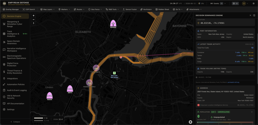
- Trade & infrastructure data: IMF PortWatch aggregations, multiple ports & radio communications sources, trade routes, dredged channels, undersea cables
- Sanctions & risk management data: OFAC, OpenSanctions, several Port State Control (PSC) Memoranda of Understanding (MoUs) detention & seizure databases
As with any of our other data sources or produced intelligence, you can visualize and interact with these datasets on the Common Operating Picture (COP) and within the right panel where cross-correlation of other data is shown.
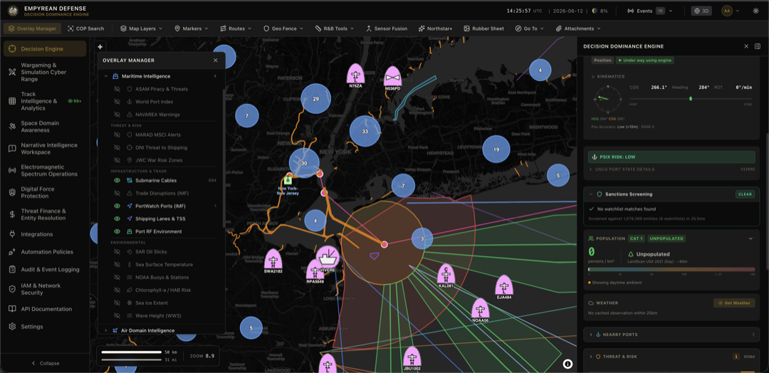
Like with anything else in the product, toggling the Overlay Manager lets you enable or disable additional overlays on the map to help with your situational awareness tasks. You can turn on submarine cable runs, NASA FIRMS fires, Cerulean oil spills, port infrastructure, radio infrastructure, or otherwise as you desire.
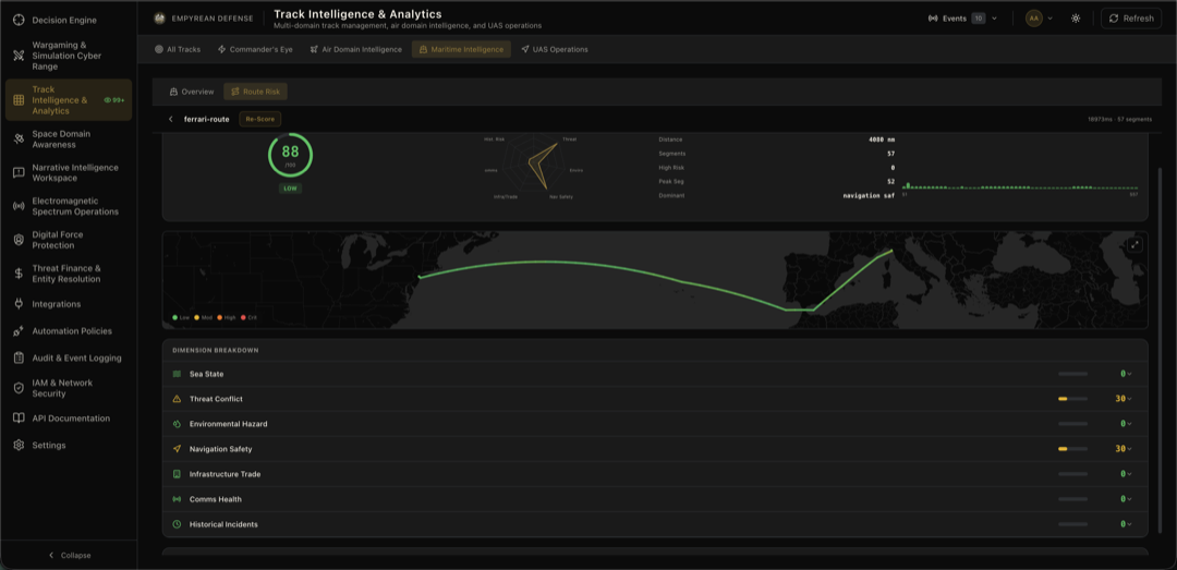
All of this culminates in the Maritime Route Risk Reporting feature we have within MARINT that takes any imported KML or COP Route and uses a proprietary seven-legged scoring methodology to determine risk to a specific destination. We take the following dimensions into consideration: sea state, threat & conflict intelligence, environmental hazards, navigation safety, infrastructure, communications health, and historical incidents.
Air Domain Intelligence (ADI)
The security and situational awareness in the air domain is just as important as the maritime domain. Whether its deconflicting civilian traffic from firefighting or military flights or deconflicting all of those from Unmanned Aerial Systems (UAS), we built ADI to provide answers on both scenarios to further provide force protection and UAS Traffic Management (UTM) capabilities organically within the platform. This further feeds into our emerging Counter UAS capabilities, which we have written about in Sense, Make Sense, Act: How to Conduct Counter-UAS From Sensors to Deployments.
To that end, we built out the Air Domain Intelligence & UTM capability within the tool and onboarded a large amount of FAA and related data sources during our previous release to provide traditional airspace monitoring and UTM as well. You can take a look at our Integrations page to see what we have, but between the Threat Finance & Entity Resolution (TFER) feature and our normal geotechnical datasets we cover everything from background noise data for Part 150, population density for the upcoming Part 108 ruling, and several other datasets such as obstacles, powerlines, LAANC grids, aircraft registration data, corporate registration, wildlife migration data, and more.
Now when you select an ADS-B or radar track on the Common Operation Picture (COP) map view, you have air domain enrichment components that show up.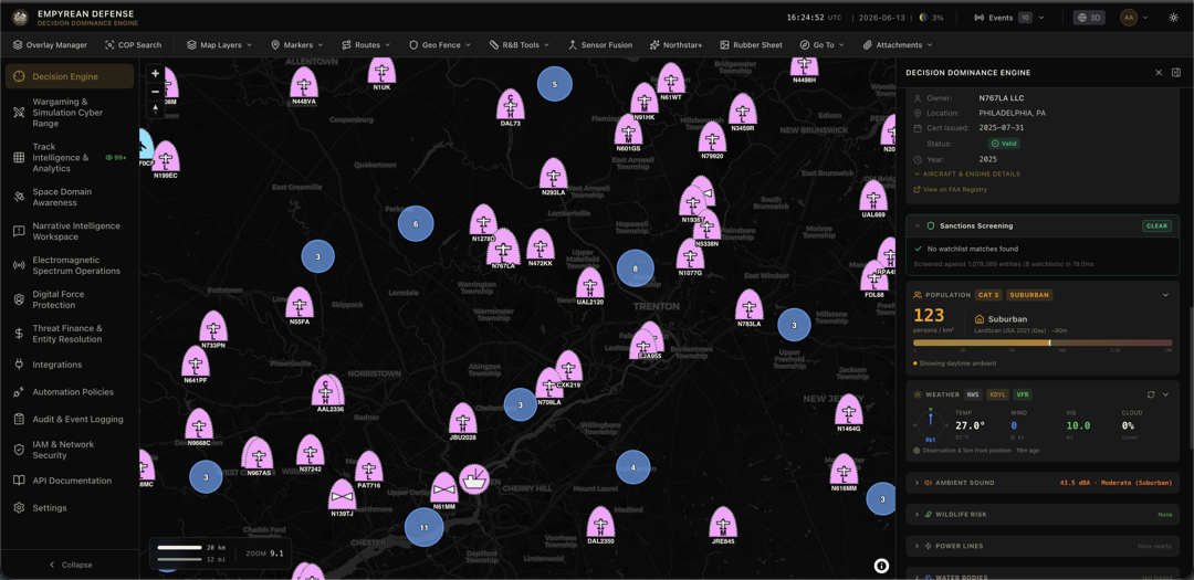 In this screenshot, you can see aircraft registration, automated sanctions screening, and live-updating overlays on weather, population, noise, and several other categories. These same components show up for UAS tracks as well whether they are contributed by ADS-B, radar, or Remote ID scanners such as DroneTag RIDER or DroneTag SCOUT which we also support as first party integrations.
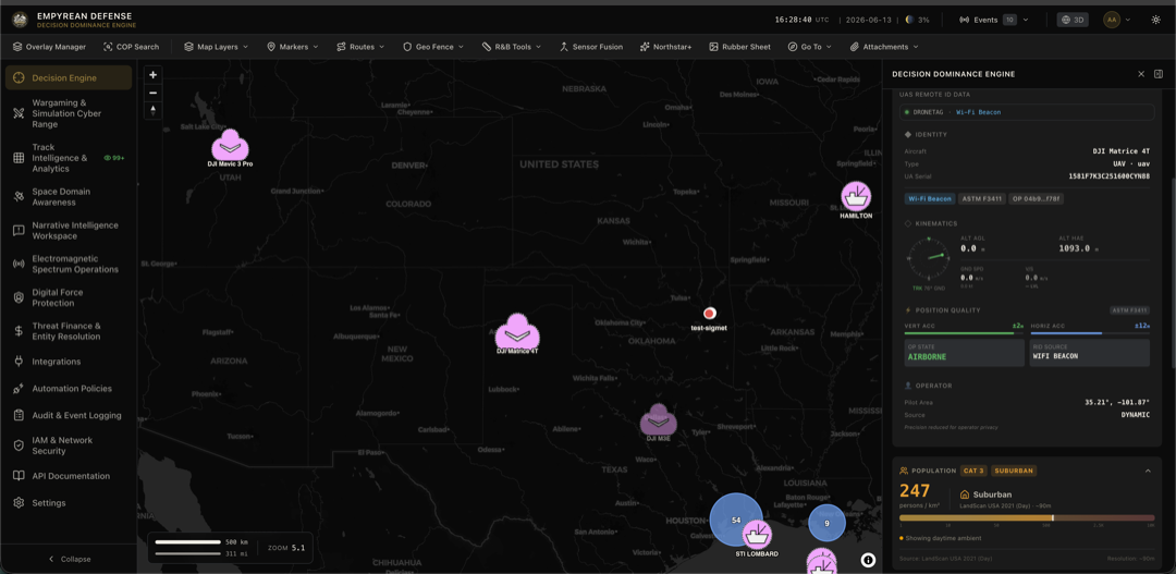 Our Remote ID tracks are sensor agnostic, while we are deepening our partnership with DroneTag to support air gapped usage of locally deployed sensors. We can extend this to nearly any other type of remote ID/open drone ID sensor as long as they’re compliant with ASTM 3411-22a schemas. Our data fabric and connector integration mesh can handle any type of device no matter the physical or logical connectivity. In the future, we will open-source some of our own Rust-based decoders and scanners as well to support teams with lower budgets who need to improve sensor coverage for UTM and Counter UAS use cases.
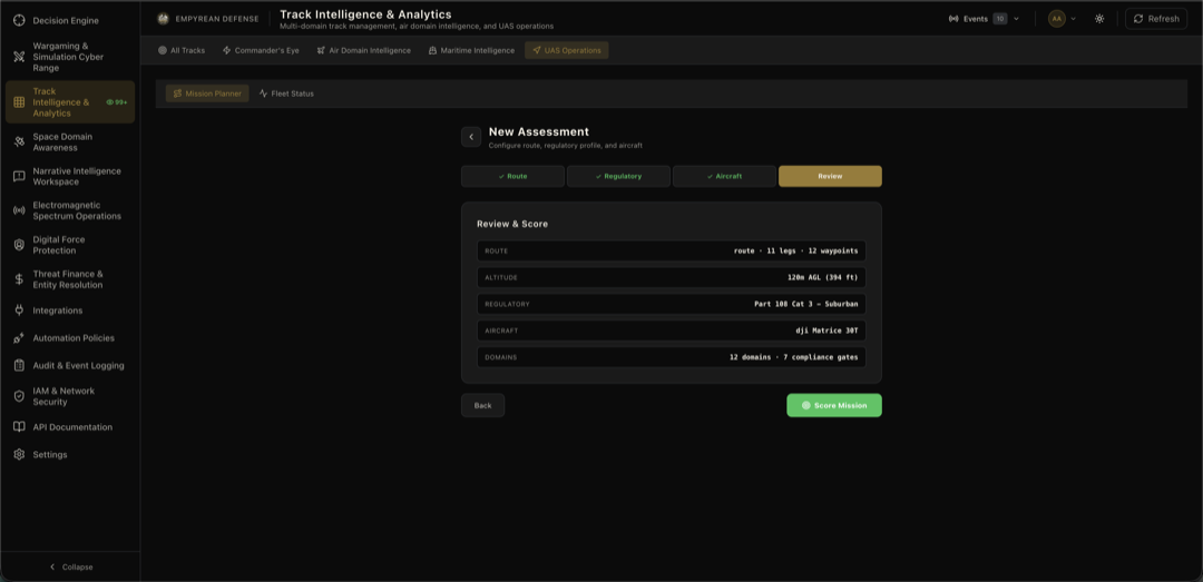
All these geotechnical, contextual, and sensor integrations culminate in the crown jewel of ADI and UAS Operations in our Safety Risk Management scoring capability. From any Route on the COP or imported KML/KMZ package from flight management tools or GIS such as Google Earth or ArcGIS, we provide pre-flight safety scores by looking across 21 different dimensions.
We have a database of several dozen NDAA-compliant and commercial drones used by public safety agencies, militaries, and other organizations that consider the C2 uplinks, battery size, flight time, weights, and more. From there, you select different regulations you want to assess the flight safety against such as Part 91, Part 107, Part 108, Part 135, or Part 137 and any exemptions you wish to take into account. For instance, a powerline inspection exemption will not render a failure due to proximity to high voltage power lines.
We are in the midst of our Part 146 NTAP with the FAA and working with several partners to be able to provide this functionality in a self-serve and subscription-based manner soon as the industry prepares itself for the Part 108 final rule. Our Joint All-Domain Operations (JADO) spatiotemporal data fabric is well suited to provide the full awareness engine for UTM and Counter UAS, and we have the physics backend to simulate flights, crash consequence, and other exciting direct action to help keep air commuters, drone pilots, airports, and agencies safer.
There is a lot more to showcase with ADI and UAS Operations. We encourage anyone who wants to see more to get into contact with us via the email or form on the website and we’d be more than happy to talk to you about how our capabilities can help foster safe risk management for your UAS operations - BVLOS or otherwise.
Conclusion
This first volume of the Empyrean Defense Release Log is one of what will be many in the series. Things move quickly here in response to feedback from our industry partners, customers, and regulatory agencies that we work with day in and day out. Maritime Intelligence, Air Domain Intelligence, and UAS Operations is only a small subset of the full changes. Be sure to refer to our other Capability Recipes as well as our Integrations catalog to keep up with the latest changes and use cases that we can support.
We are continuing to invest in these capabilities as well as capabilities across Space, Information, Electromagnetic, Financial Intelligence, and Digital Force Protection capabilities. Some of the changes on the horizon include more integrations and counter Ubiquitous Technical Surveillance sensing capabilities within Digital Force Protection. Onboarding additional data sources and improved investigations within the Counter Finance & Entity Resolution capability and expanding our Ground domain support with EO/IR ISR machine learning, vehicular detection, and vastly expanding the amount of UAS and USSV Ground Control Station (GCS) and fleet management software suites we integrate with.
If we can help you with any challenges you face across any domain, reach out to the team for a demo and to talk more deeply about establishing a commercial relationship. If you are a Partner, we are more than happy to talk about channels and co-selling as well.
