RF Coverage and Link Planning
Planners need to know where a radio, sensor, or drone link will actually reach, given the terrain and today's weather, not a circle on a map.
How it's done today
Most coverage planning still happens in tools built for RF engineers, or not at all.
Range rings
A circle drawn at a radio's rated range, ignoring the ridge, the buildings, and the rain.
Standalone propagation software
Accurate, but it needs an RF engineer, terrain data, and time, and its results don't connect to the live operational picture.
Carrier coverage maps
Marketing-grade cellular maps that show where a carrier claims service, not how redundant it is or what it looks like at 400 feet.
Fixed fade margins
A margin added once for bad weather, instead of modeling the conditions that actually exist.
Where it breaks
Circles lie. Terrain creates shadows and extends reach in ways a circle can't show, so planned coverage and real coverage diverge.
Weather changes the answer. Rain and humidity shrink high-frequency links and radar coverage. A plan briefed in the morning can be wrong by the afternoon.
Planning is disconnected from operations. Coverage studies live in files, not next to the tracks and sensors they describe.
Unknown emitters stay unknown. A detected signal with no location estimate is hard to act on.
With Empyrean
Empyrean runs standard, published propagation models with live terrain and weather, and shows the results on the same map as your operations.
Terrain-shaped coverage
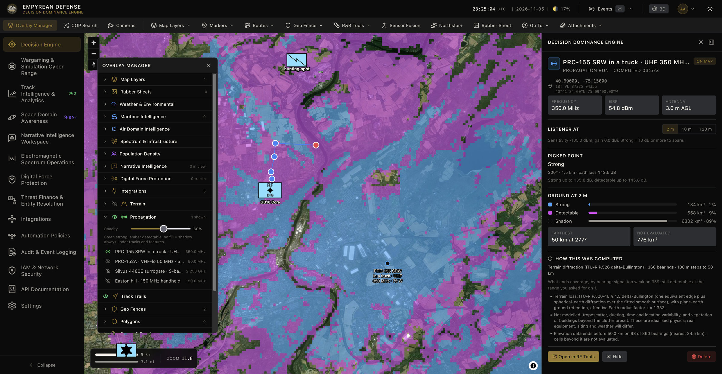
Coverage is computed along hundreds of radials using Fresnel-zone and knife-edge diffraction or the Longley-Rice Irregular Terrain Model, producing real coverage shapes with good and marginal zones.
Today's weather, not clear sky
ITU-R gaseous and rain attenuation models use live conditions, so coverage and link margins reflect the weather that's actually there.
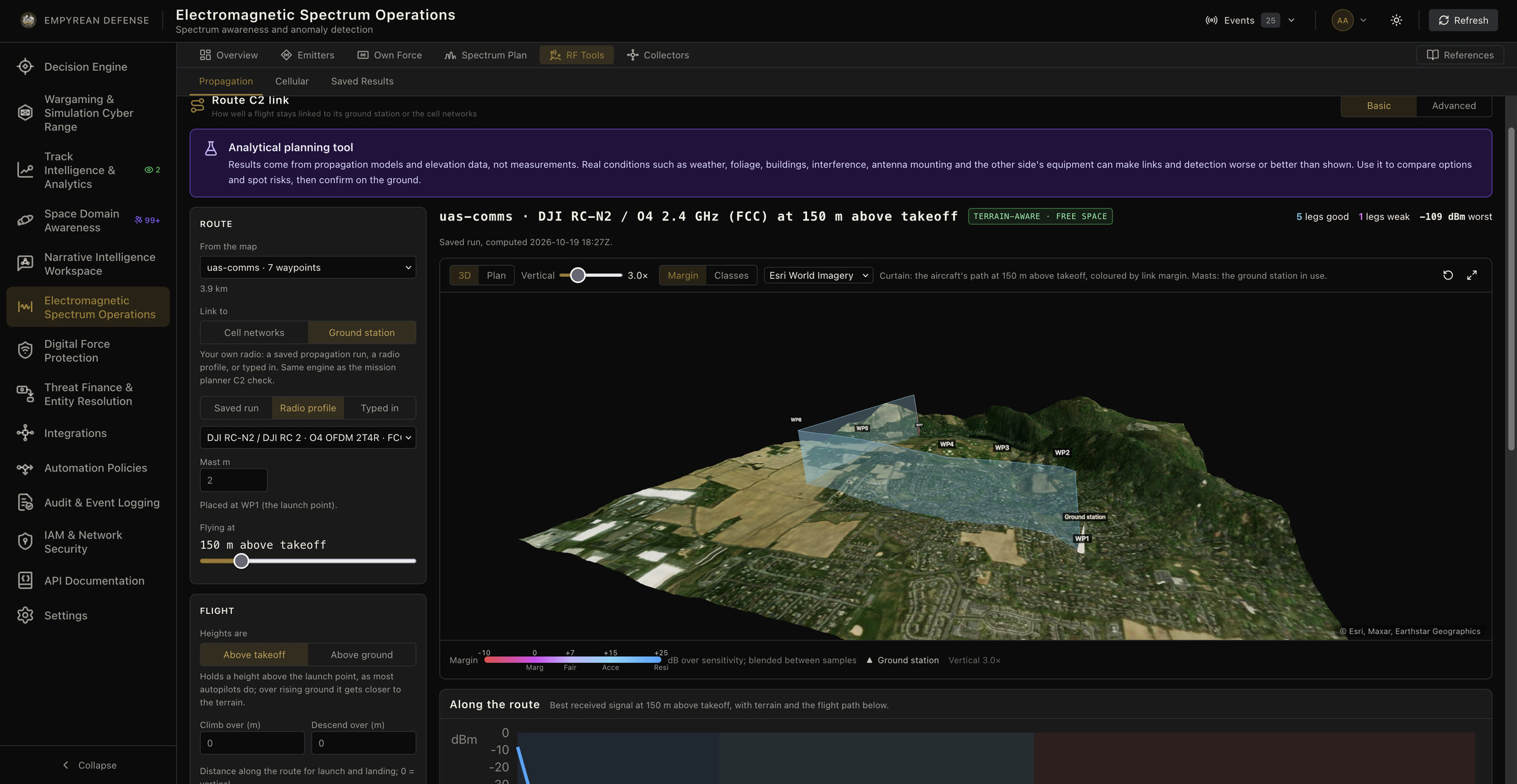
UAS command-and-control links along a route
Planned routes are sampled leg by leg and scored from robust to no link, following the link budget approach in RTCA DO-377B.
Emitter range estimates
From a received signal level, Empyrean estimates the band of distances an unknown transmitter is likely to be in, shaped by terrain.
Cellular coverage and redundancy
Using the global OpenCellID tower database, Empyrean maps coverage gaps and carrier diversity, including along routes and at altitude for drones.
Fast enough to ask what-if
Thousands of path-loss calculations run interactively, so you can move an emitter and see the coverage change.
In practice
A state UAS program plans a 25 km beyond-visual-line-of-sight inspection route along a river valley. Empyrean samples the route every 500 meters and scores the command-and-control link from the ground station. Two legs behind a ridge come back marginal, and with the afternoon's forecast rain they drop to poor. The planners add a relay site before the flight instead of discovering the gap in the air, and the cellular analysis shows which carriers can serve as a backup link along the route.
Coverage shows up on the live operational picture, not in a separate file. Pick any point to see how strong the signal is there, which way coverage ends on each bearing, and exactly which model and assumptions produced the result.
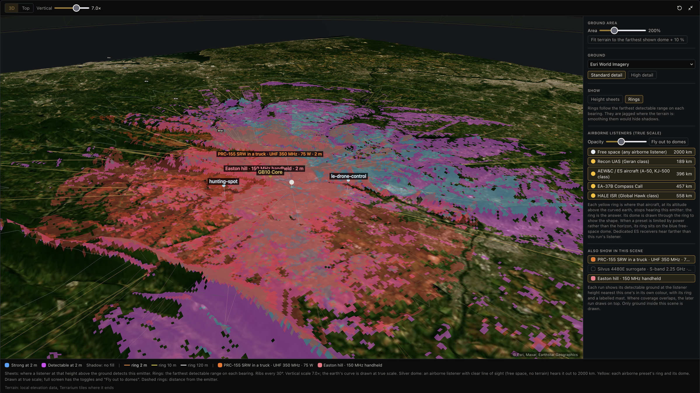
In 3D, several emitters can be compared in one scene against terrain, along with how far airborne listeners at different altitudes could hear each one.
Standards behind the models
| Standard | Used for |
|---|---|
| Friis (1946) | Free-space path loss baseline |
| Okumura (1968) and Hata (1980) | VHF/UHF propagation, 150-1500 MHz |
| EURO-COST 231 (1999) | 1500-2000 MHz extension |
| 3GPP TR 38.901 | 5G and cellular channel model, 0.5-100 GHz |
| ITU-R P.526 | Fresnel zones and knife-edge diffraction |
| ITU-R P.676 | Gaseous atmospheric attenuation |
| ITU-R P.838 | Rain attenuation |
| NTIA Report 82-100 | Irregular Terrain Model (Longley-Rice) |
| RTCA DO-377B | UAS command-and-control link budgets |
What you still need
- Field measurements for critical links. Models are predictions; validate links that matter with real measurements.
- Good inputs. Results depend on terrain data quality and on assumptions such as transmitter power for unknown emitters.
Built on
Further reading
Frequently asked questions
Which propagation models does Empyrean use?
Free-space path loss, Okumura-Hata, COST-231 Hata, and 3GPP TR 38.901 for analytical estimates; Fresnel-zone and knife-edge diffraction (ITU-R P.526) and the Longley-Rice Irregular Terrain Model for terrain; and ITU-R P.676 and P.838 for atmospheric and rain attenuation.
Can it plan drone BVLOS command-and-control links?
Yes. It samples a planned route, computes the link margin from the ground station at each point with terrain and current rain, and scores each leg, following the link budget approach in RTCA DO-377B.
Can it locate an unknown transmitter?
From a single sensor it estimates a range band, shaped by terrain, given an assumed transmitter power. Combining sensors narrows the location further.
Do I need to be an RF engineer to use it?
No. You choose the model fidelity, and the results are shown as coverage areas, link scores, and range bands on the map.
Read next

See real coverage for your area
Tell us the radios, sensors, or routes you're planning, and we'll show you terrain- and weather-aware coverage.